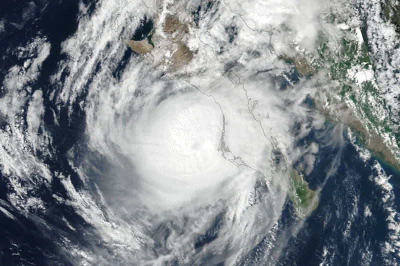
Hurricane Polo made landfall in Baja California Sur around 11 p.m. local time on September 28, ending a week of violent strengthening that carried it to category 5 just six days earlier. The storm then made a second landfall near Guaymas around midday on September 29, after weakening enough for forecasters to say it likely reached shore as a category 2 storm.
That shift matters because Polo is moving through one of the busiest Pacific seasons in years. By September 28, the northeastern and central Pacific had produced 20 named storms and nine hurricanes, far above the 1991-2020 averages of 13.5 named storms and 7.4 hurricanes by that date. Accumulated cyclone energy in the Northeast Pacific was also more than twice the norm, a sign that the basin has spent much of the season churning out storms with unusual efficiency.
Lauren Dauphin produced NASA Earth Observatory images of the basin using data from DSCOVR EPIC and VIIRS, and those satellite views captured just how crowded the Pacific had become. On September 27, an EPIC image showed multiple storms lined up across the ocean, a visual match for the numbers that had already made this season stand out. The setup has been favored by El Niño, which had been underway since June and is known to encourage tropical cyclone activity when warm water and low wind shear line up over the ocean.

Polo’s rise and fall tell the sharper part of the story. It underwent extreme rapid intensification over unusually warm ocean water, reaching category 5 on September 22 before weakening on the approach to land. The National Hurricane Center warned of dangerous winds, storm surge, heavy rains, flooding and mudslides in parts of Baja California Sur and Sonora, a reminder that a storm does not need to keep its peak strength to remain dangerous once it nears shore.
The wider threat did not stop there. Polo and its remnants, together with moisture from Post-Tropical Cyclone Odalys, were expected to bring more heavy rain and flood risk to the southwestern U.S. and the southern Plains over several days. Tropical Storm Rachel was also tracking parallel to the southwest Mexico coast, with forecasters calling for strong winds and dangerous surf and rip current conditions. In Hawaii, Hurricane Nolo did not make landfall, but it still dropped more than 12 inches of rain on parts of Maui and the Island of Hawaiʻi, flooding roads, toppling trees and triggering landslides.
NASA’s Disasters Program, working with FEMA, was supporting the State of Hawaii’s response to Hurricane Nolo and said it would post maps and data products on its open-access mapping portal as new information became available. For now, Polo is the clearest measure of what this season has become: a Pacific basin running hot, with storms that can strengthen fast, weaken before landfall and still leave several regions bracing for the next round of rain.