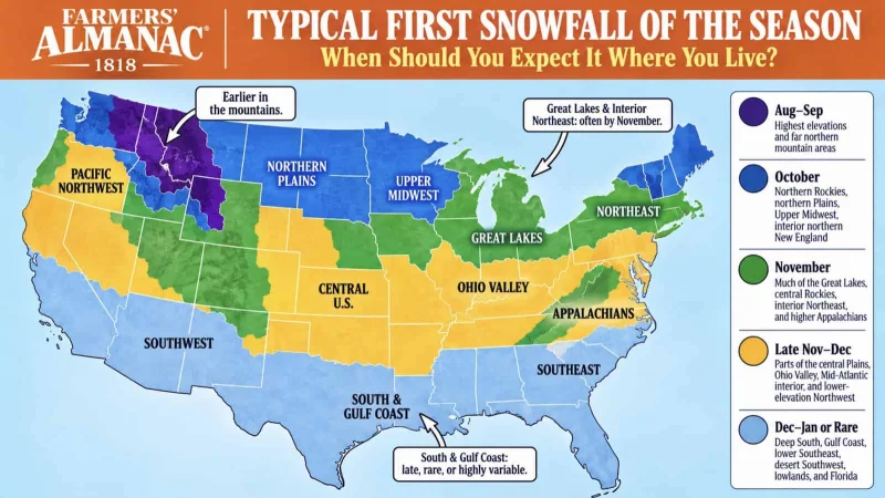
Brian Brettschneider has mapped 45 years of snow records to show when the first snowfall of the year typically arrives across the United States and Canada. His Farmers' Almanac First Snowfall Map turns decades of NOAA records into a regional guide for the season’s first flakes.
The timing matters now because snow has already started to show up in a few mountain areas, and NOAA’s Climate Prediction Center has flagged a strengthening El Niño pattern heading into winter 2026-27. Brettschneider used NOAA’s Global Historical Climatology Network and calculated the median first-snow date at every station with at least 20 years of complete snow data since the winter of 1980-81, giving readers a rare look at where winter arrives early and where it lingers back.
The map draws nine color-coded bands, and the broad pattern is easy to read. Northern Canada and Alaska’s interior sit in the earliest bands, with some places seeing their first snow before mid-September. At the other end, the Gulf Coast, the Deep South and the Desert Southwest often do not see meaningful early snow at all, and parts of Texas, Florida and Southern California are so snow-starved that the data cannot produce a reliable median. Climate.gov has separately used NOAA’s 1981-2010 climate normals to estimate when a location has at least a 50% chance of measurable snow on the ground, but Brettschneider’s map is about the first time snow usually sticks long enough to count.

That broad geography still hides a lot of local noise. The Rockies can carry a year-round snow risk on high points, while valleys only a few miles away may wait until November or December for their first flakes. Farther east, once the first hard cold front of autumn crosses the still-warm Great Lakes water, it can come out loaded with moisture, which is why lake-effect snow tends to reach Michigan and upstate New York early. Even then, the pattern is not uniform: early snow pushes farther south through the high Plains than it does across the Midwest at the same latitude, because the Rockies help channel cold Canadian air straight down the Plains before the season’s first storms are settled in.
That is why a regional map is useful, but not final. In Dodge City, Kansas, NOAA’s records show first snow has landed anywhere from mid-September to early January over 65 years, a swing of nearly three and a half months. Boston has strung together several early-snow seasons in its record, while towns just up the coast in New England have not followed the same run. The message in the data is clear: latitude and elevation set the frame, but one storm can still move the first flakes by weeks.
The 2026-27 season is already giving the map a live test. Crystal Mountain, Washington, picked up a dusting across its upper elevations over the weekend before Sunday, Aug. 30, and by that Sunday Banff Sunshine, Alberta, and Kicking Horse, British Columbia, had both reported fresh accumulation on higher terrain. NOAA’s Climate Prediction Center says it has more than 90% confidence in a strengthening El Niño pattern, and that matters because El Niño winters typically bring a wetter, more active storm track across the southern U.S. and a drier pattern across the Pacific Northwest and Northern Rockies. The first snow will still be local, but the next round of weather could tilt the odds sooner in some places and later in others.