Tulsa and Oklahoma City are facing a cooler, unsettled Tuesday as storms move across Oklahoma, bringing the risk of hail, damaging winds and periods of heavy rain. The latest forecast shows temperatures well below recent late-spring warmth, with more showers and thunderstorms possible through the end of the week.
Storms Push Across Oklahoma On Tuesday
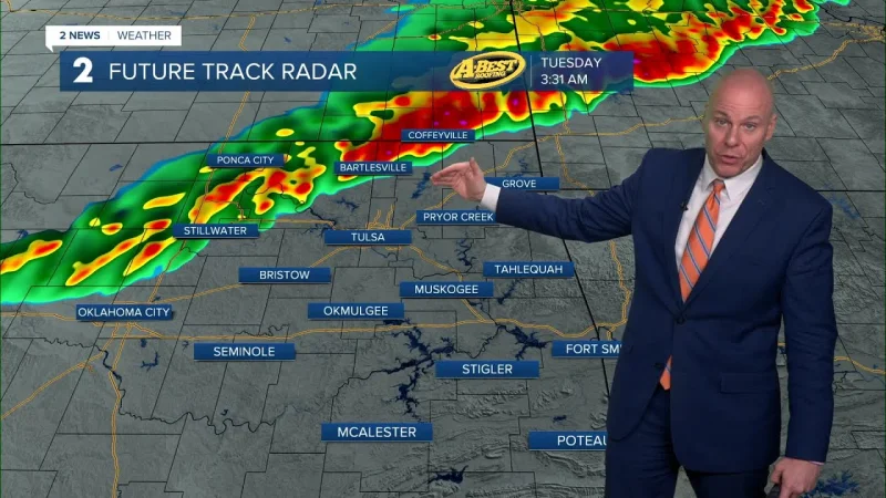
Rain was affecting Tulsa early Tuesday, with temperatures near 63 degrees and a forecast high of 66. Oklahoma City started the day cloudy and cooler, near 57 degrees, with a projected high around 61.
The main concern for both metro areas is not extreme heat, but the strength of thunderstorms moving through the state. Storms in and near Tulsa may produce hail and damaging wind gusts, especially where stronger cells form along and ahead of a cold front. In Oklahoma City, early storms could also bring hail and damaging winds before conditions turn more variable later in the day.
The severe risk is not expected to affect every neighborhood equally. The strongest storms are most likely where instability, lift and the front line up at the same time. That means some communities may see heavy rain and gusty wind while others experience mainly clouds, light rain or a brief rumble of thunder.
Tulsa Weather Turns Cooler, Cloudy And Unsettled
Tulsa’s Tuesday forecast marks a noticeable shift from warmer May conditions. The city is expected to remain under considerable cloud cover, with rain and thunderstorms most likely during the morning and additional storm chances possible nearby.
After Tuesday’s high in the mid-60s, Tulsa is forecast to stay cloudy Wednesday with a high near 70. Rain chances return Thursday, when a couple of showers and thunderstorms are possible and temperatures remain in the lower 70s.
By Friday and into the Memorial Day weekend period, Tulsa should turn more humid. Highs are expected to climb into the upper 70s and lower 80s, but the pattern remains unsettled. Scattered storms remain possible Friday, Saturday and Sunday, making outdoor plans dependent on timing and location rather than a clean all-day forecast.
OKC Weather Includes Storm Threat And More Rain Chances
Oklahoma City’s Tuesday weather is also being shaped by clouds, cooler air and a passing storm system. A strong thunderstorm is possible during the morning, followed by intervals of clouds and sun later in the day.
The cooler air will keep temperatures far below typical late-May heat, with a high near 61. Wednesday looks warmer but still mostly cloudy, with highs returning to the lower 70s.
Thursday brings the next more organized rain chance for Oklahoma City. Showers and thunderstorms are likely, and downpours may create ponding on streets in heavier cells. Localized damaging wind gusts cannot be ruled out if stronger storms develop.

The city’s late-week forecast remains humid and unsettled. Highs are expected to rise into the upper 70s Friday through Monday, with periodic thunderstorm chances continuing into the weekend.
Why The Forecast Matters Now
May is one of Oklahoma’s most active severe-weather months, and even a moderate-looking forecast can change quickly when storms develop along a front. The current setup includes enough instability for storms to produce hail and wind damage, especially where thunderstorms organize into stronger lines or clusters.
The bigger concern for many residents may be repeated rain chances. One storm may not cause widespread problems, but several rounds over multiple days can raise the risk of slick roads, poor drainage flooding and delays for commuters.
For Tulsa, the storm risk is tied most closely to Tuesday’s front and later rounds of rain late in the week. For Oklahoma City, Tuesday morning storms and Thursday’s wetter setup are the main periods to watch.
Travel, Schools And Outdoor Plans Could Be Affected
Drivers in both metro areas should be ready for sudden downpours, reduced visibility and standing water in low-lying spots. Hail-producing storms can also create brief but hazardous road conditions, especially during heavier bursts.
Outdoor events may not need to be canceled across the board, but the forecast supports flexible planning. The most practical approach is to monitor radar before leaving, have access to alerts and identify indoor shelter in case storms intensify.
For schools, workplaces and evening activities, the key issue is timing. Conditions may improve between rounds, but that should not be treated as an all-clear for the entire day or week.
More Storm Chances Continue Into The Weekend
The unsettled pattern is expected to persist beyond Tuesday. Tulsa is forecast to see highs near 70 Wednesday, 71 Thursday, 78 Friday and 78 Saturday, with additional storm chances returning late in the week. Oklahoma City is expected to warm from the lower 60s Tuesday to the lower 70s Wednesday and Thursday, then into the upper 70s by Friday.
Neither metro area is looking at a long stretch of clear, dry weather in the immediate forecast. Instead, Oklahoma will remain in a spring pattern marked by clouds, humidity, periodic thunderstorms and changing local impacts from one round to the next.
Residents should keep weather alerts enabled, especially during the morning and evening commute windows, and treat severe thunderstorm warnings seriously. The most likely hazards remain hail, damaging winds and heavy rainfall, with the forecast continuing to depend on how storms organize as they cross the state.