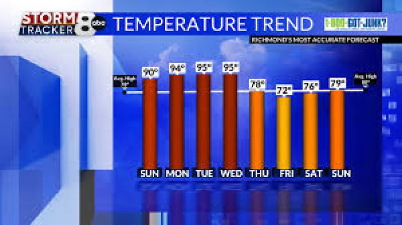
After a chilly start to May, the Midwest and Northeast are about to trade spring jackets for summer heat. Forecasters said the weather pattern is expected to flip over the next few days, with temperatures climbing into the 80s and, in some places, near 90 degrees.
Tyler Roys said the shift will not arrive all at once. Baltimore, New York City, New Haven, Providence and Boston are not necessarily expected to see a heat wave on Monday, May 18, he said, but many of those same places will try to shoot into the upper 80s and lower 90s on Tuesday, May 19, and Wednesday, May 20.
That kind of jump matters because it will come fast. In parts of the mid-Atlantic and Southeast, the highest temperatures of the year so far could hit early next week, turning a brief warm spell into the season’s first real taste of summer heat. AccuWeather said the surge of warmth and humidity should spread across much of the Midwest and East, and a cold front is then expected to move through on Wednesday, May 20, trimming the heat back for many areas.
Dan DePodwin said the air will feel very different from the dry warmth that has marked some of the spring’s earlier mild stretches. Dew points in the 60s early next week, he said, will be quite noticeable. That means the heat will not just be a number on a thermometer; it will feel heavier, stickier and harder to shake, especially in cities where the onshore flow keeps some places closer to average on Monday before the real climb begins.
The pattern is also different from the start of May, when many locations were still dealing with a chill that made frost concerns part of the conversation. Roys said most places in the Ohio Valley and the valleys of the Northeast and Mid-Atlantic do not necessarily expect any frost going forward. Some higher elevations in northern New England and the upper Great Lakes may still need frost advisories and freeze warnings, but the broader trend has turned warmer.
There is, however, a sharp reminder that warm air does not erase spring hazards overnight. The National Weather Service in New York warned that cold water temperatures remain in the lower 50s this weekend. It said those conditions can quickly cause hypothermia and physical incapacitation to anyone suddenly immersed in the water, and urged people going out on small boats, canoes or kayaks to plan accordingly and use extreme caution.
That warning lands at the same moment the air is turning summerlike across parts of the region, a contrast that can catch people off guard. A sunny afternoon can make a river, bay or lake look less threatening than it is, but the water has not caught up to the weather yet.
Roys said the larger pattern will not lock in a full summer regime just yet. For the Great Lakes, Ohio Valley and into the Northeast and Mid-Atlantic, he said, the point where summer heat truly takes control of the weather pattern will not really arrive until the second half of the summer season. That means next week’s warmup may be dramatic, but it is not the final word.
The result is a short burst of heat, humidity and near-summer conditions, followed by a front that should cool things down again. For now, the biggest question is not whether temperatures will rise — they will — but how long people will get to enjoy the warmth before the next round of change arrives on Wednesday.