


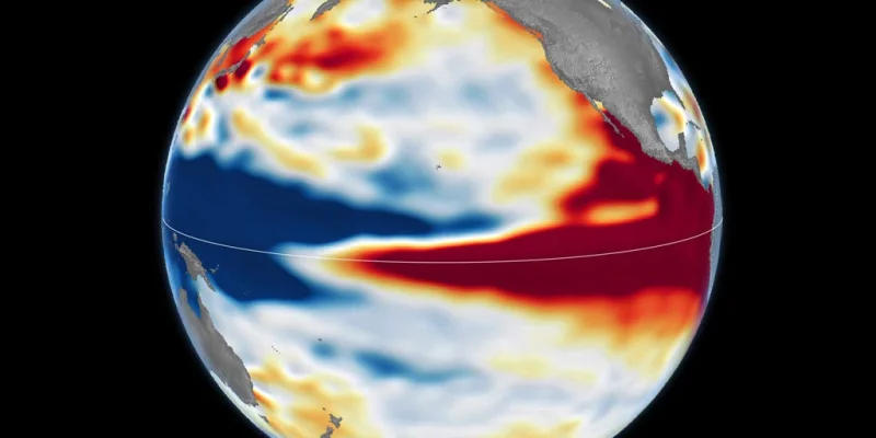
FOX Weather said this year's developing Super El Niño could become one of the strongest on record, putting a rare winter setup back in focus as cold season nears. The comparison is not casual: the forecast is being measured against the 1997–98 and 2015–16 El Niño events, two of the most powerful on record.
That is why people searching for a NOAA Washington, D.C. winter forecast are seeing El Niño front and center today. El Niño is the Pacific Ocean’s warm phase, and when unusually warm water builds across the equatorial Pacific it weakens the trade winds, shifts tropical rainfall eastward and can nudge the jet stream. In winter, that pattern often brings wetter conditions to the southern U.S. and warmer, drier weather to parts of the northern U.S. and Canada.
Stephen Morgan was among four meteorologists in the FOX Weather coverage explaining why this year’s signal has drawn so much attention. On Oct. 12, NASA satellite imagery showed a broad red band across the central and eastern equatorial Pacific, a sign of higher-than-normal sea levels as warm water expanded and surged eastward toward South America. Blue shades marked lower-than-normal sea levels, while white indicated near-average conditions.

The old benchmarks still matter because they show what a powerful El Niño can do. The 1997–98 event sent a huge pool of warm water surging east across the Pacific and reached all the way to South America. It was felt worldwide and fueled fires in Indonesia and the Amazon, drought-driven crop failures in Southern Africa, and heavy rain and coastal flooding in Southern California and the southern U.S. The 2015–16 event also featured exceptionally warm, elevated water across the Pacific.
But that comparison has a built-in limit. Even when an El Niño looks strong early, each one develops differently, with its own strength, duration and impacts. Long-range forecasts suggested the 2026–27 event could rank among the strongest in recent history, yet the real test is how the atmosphere responds as winter unfolds. For Washington, D.C., the broader signal matters more than any single snapshot: a stronger El Niño can tilt the odds on storm tracks and temperature patterns, but it does not write the season in advance.
That is the part forecasters will keep watching. If this developing event keeps strengthening, it could join the class of winters that shaped weather far beyond the Pacific, but the final answer will depend on whether the ocean signal and the atmosphere stay locked together long enough to deliver it.