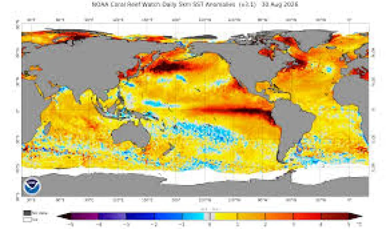
A Pacific Ocean heatwave that formed in May has pushed surface temperatures 3C to 4C above average, and it is now heading into autumn just as El Niño is expected to intensify. The result is not a pause in the warming, but a second push that could make the US West Coast wetter, stormier and more flood-prone as the year turns colder.
That is why coastal planners and weather watchers are focused on California now. Patrick Barnard said coastal water levels there are already 15cm above mean sea level, and he expects them to climb another 15cm to 30cm higher than normal during this El Niño, a shift that could sharply raise the flood frequency for coastal communities.
The heat is not limited to the surface. California has been in the grip of a marine heatwave since December, and the newer Pacific Ocean warming has spread across the north-east Pacific Ocean with enough force to stand out even to researchers who track it for a living. Andrew Leising described it as a bright red eye in the Pacific, and said it stretches across the whole ocean.
That matters because warm water changes the atmosphere above it. As ocean surfaces heat up, they evaporate more heat and moisture into the air, which can fuel heavier rainfall and more atmospheric rivers in the coming months. The same pattern is expected to increase storm surges and flooding through autumn and winter along the California coast.
The strain does not stop at the shoreline. The combined impact of El Niño and marine heatwaves is expected to reduce snowfall in the US and Canada, and Larry O'Neill said the storms that do arrive may travel farther north than usual and fall as rain at elevations that would normally see snow. The last time a huge Pacific marine heatwave, the Blob, hit this part of the ocean, it helped produce a record low snowpack in the Pacific Northwest in 2015.
That same weather pattern can also dry out land farther inland. Forecasts point to above-average warming and dry conditions across northern California, eastern Oregon, southern Idaho and Utah this autumn, raising wildfire risk just as the ocean keeps feeding the atmosphere with more heat and moisture. El Niño is a natural cycle, but this time it is expected to amplify an already rare and immense Pacific Ocean heatwave rather than offset it. What happens this winter will depend on how much those two forces overlap when the coastal flood season peaks.