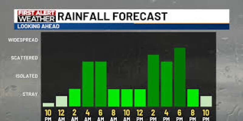
People in southeast Minnesota and northeast Iowa are facing a late-night shift in the weather, with isolated showers and storms moving in after 10 pm and a stronger threat building by Wednesday morning. The most serious window is expected from 5-8 am, when a few storms could turn strong to severe, mainly along Highway 18 in northeast Iowa.
Hail and heavy rainfall are the main hazards in that morning round. Rain should ease for a bit between late morning and early afternoon, but that break is also what will decide whether a second round can form later in the day.
That is why Wednesday matters more than a typical rainy day. The forecast does not include a First Alert Day for Wednesday because confidence is still low, but the setup still points to a meaningful storm threat for people in the path of the morning system, especially areas south of I-90 where heavy rain is a concern.
The trouble is that the later threat depends on a narrow chain of events. If the morning rain clears fast enough and the atmosphere has time to destabilize and recharge, another round of strong to severe storms could develop from 1-7 pm, with all hazards possible along and south of Highway 14. If that reset does not happen, the afternoon threat weakens sharply.
Rain totals could still add up even where storms do not turn severe. By the end of Wednesday, rainfall may range from 0.25 inch to more than 1 inch in some locations. After that, the pattern turns quieter, with cooler-than-normal temperatures in the low to mid 70s and plenty of sunshine later in the week. A few showers may need to be watched for Sunday, but the immediate focus stays on Wednesday morning and whether the sky clears enough for round two.