El Niño is knocking on the door after months of rising Pacific sea temperatures, and climate scientists now say there is about an 80% chance it forms between June and August. António Guterres warned that the warming pattern is arriving with 90 percent certainty and that El Niño conditions will pour fuel on the fire of a warming world.
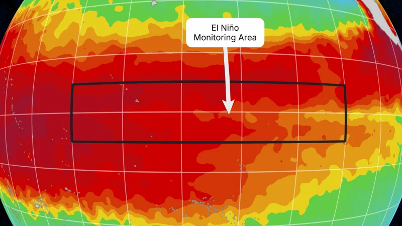
The reason people are searching now is simple: the next official NOAA Climate Prediction Center update comes Thursday, June 11, and the forecast window is getting tighter. Scientists define El Niño by sustained warming in the central and eastern equatorial Pacific, known as the Niño-3.4 region, and NOAA says the threshold is reached when sea-surface temperatures rise at least 0.9 degrees Fahrenheit, or 0.5 degrees Celsius, above average and are expected to hold for five consecutive, overlapping three-month seasons.

Weekly Niño 3.4 temperatures have recently climbed to around 0.5 degrees Celsius above average, which is close to the line but not across it yet. NOAA’s status remains neutral for now, even after NASA said its Sentinel-6 Michael Freilich satellite observer showed seas around Peru were more than 5.9 inches, or 15 centimeters, above long-term averages in mid-May.
That gap matters because El Niño can redirect rainfall, deepen drought, shift winter storm tracks and alter hurricane activity while also pushing global temperatures higher. The World Meteorological Organization says the developing pattern could persist into late 2026, with about a 90% chance it lasts that long, and many forecast models suggest it could become moderate or even strong by then.
Guterres has already framed the stakes in blunt terms, saying the world should treat El Niño as an urgent climate warning because its impacts can travel farther and cross borders with devastating speed. The unresolved question is how strong this one becomes once the Pacific finally tips, and which regions will pay first when it does.