A developing El Niño weather pattern is increasingly likely to shape weather across the United States, Canada, Australia and other parts of the world through late 2026, with forecasters warning that its effects could include a quieter Atlantic hurricane season, hotter global temperatures and major shifts in rainfall.
The latest U.S. climate outlook says El Niño is likely to emerge soon, with an 82% chance during May through July and a 96% chance that it continues through the Northern Hemisphere winter of 2026-27. The signal has strengthened sharply in recent weeks, although forecasters still caution that the eventual intensity remains uncertain.
What The El Niño Weather Pattern Means
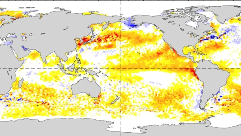
El Niño is part of the El Niño-Southern Oscillation, a recurring climate pattern driven by changes in ocean temperatures and winds across the tropical Pacific. During El Niño, unusually warm water spreads across the central and eastern equatorial Pacific, altering atmospheric circulation far beyond the ocean basin where it begins.
Those changes do not create the same weather everywhere. Instead, El Niño shifts the odds. It can make some outcomes more likely, such as warmer global temperatures or wetter conditions in parts of the southern United States, while making other outcomes less likely, such as an extremely active Atlantic hurricane season.
That distinction matters because El Niño is not a daily weather forecast. It does not guarantee a storm, drought, flood or mild winter in any single city. It is a large-scale climate driver that changes the background conditions under which local weather systems develop.
NOAA Sees El Niño Emerging By Summer
The strongest recent signal came from the U.S. Climate Prediction Center, which said the tropical Pacific remains in neutral conditions but is warming quickly. Sea surface temperatures across the central and eastern Pacific have moved near to above average, and climate models now favor El Niño formation by early summer.
The agency’s May update said confidence has increased since April, but not enough to lock in how strong the event will become. No single strength category dominates the forecast, and forecasters noted that the strongest El Niño events depend on sustained coupling between the ocean and atmosphere through summer.
That means the next several months are critical. Warm water below the surface can support further development, but atmospheric winds and pressure patterns must reinforce the ocean warming for a stronger event to take hold.
Atlantic Hurricane Season Could Be Less Active
One of the most immediate effects is on the 2026 Atlantic hurricane outlook. U.S. forecasters expect a below-normal season, with 8 to 14 named storms, 3 to 6 hurricanes and 1 to 3 major hurricanes.
El Niño tends to suppress Atlantic hurricanes by increasing wind shear, which can tear developing storms apart before they strengthen. It can also promote sinking air and drier conditions across parts of the Atlantic basin, making tropical development harder.

A quieter forecast does not mean coastal areas are safe. A single hurricane can still cause severe damage if it strikes a populated coastline. Rapidly forming storms near the Gulf Coast, Caribbean or Southeast coast can also leave less time to prepare, even in years when the total number of storms is lower.
Australia Faces A Warmer, Drier Risk
Australia is also watching the El Niño shift closely. The Bureau of Meteorology has said ENSO remains neutral but shows signs of possible El Niño development, with rapid warming in the Niño3.4 region since early March.
For much of eastern and southern Australia, El Niño often increases the chance of warmer and drier conditions, especially during winter and spring. That can raise concern for agriculture, water storage, heat stress and bushfire risk later in the year.
The last El Niño, which developed in 2023 and continued into early 2024, coincided with an exceptionally dry period in Australia when other climate drivers also played a role. Forecasters are therefore watching not only the Pacific, but also the Indian Ocean Dipole and regional sea-surface patterns that can amplify or soften El Niño’s effects.
Canada And The U.S. Could See Winter Impacts
For North America, El Niño’s strongest seasonal influence often appears in winter. Typical patterns can include milder conditions across parts of Canada and the northern United States, wetter weather across parts of the southern U.S., and shifts in the jet stream that affect storm tracks.
Those impacts are not uniform. The Pacific Northwest, the Prairies, the Great Lakes, California, Texas, Florida and Atlantic Canada can all experience different outcomes depending on the strength and placement of Pacific warming and how it interacts with other climate patterns.
This is why seasonal outlooks are written in probabilities rather than guarantees. El Niño may tilt the odds, but Arctic outbreaks, atmospheric rivers, nor’easters, drought patterns and local ocean temperatures can still produce sharp regional surprises.
Why Forecasters Are Urging Caution
The growing confidence around El Niño comes with an important warning: spring and early summer forecasts can still carry uncertainty. Climate scientists often refer to a spring predictability barrier, a period when ENSO forecasts have historically been harder to pin down months in advance.
Even so, several major forecasting centers now agree that the odds favor El Niño development in 2026. The key unanswered question is whether it becomes weak, moderate, strong or exceptionally strong.
That strength will help determine how much influence the pattern has on global temperatures, rainfall extremes, hurricane activity and winter storm tracks. A stronger event would raise the chance of more pronounced impacts, but even then, it would not make every regional outcome automatic.
For now, the practical message is clear: El Niño is likely on the way, and governments, farmers, energy planners, emergency managers and coastal communities should treat the forecast as an early-warning signal. The pattern may reduce some risks, including Atlantic hurricane numbers, while increasing others tied to heat, drought, flooding and disrupted seasonal weather.