A new El Niño weather pattern is increasingly likely to develop in 2026, raising the odds of major shifts in rainfall, temperatures, drought risk and hurricane activity across parts of the world. The latest federal outlook places the Pacific climate cycle on watch, with forecasters warning that confidence has risen sharply even as the eventual strength of the event remains uncertain.
El Niño Watch Signals A Fast-Changing Pacific
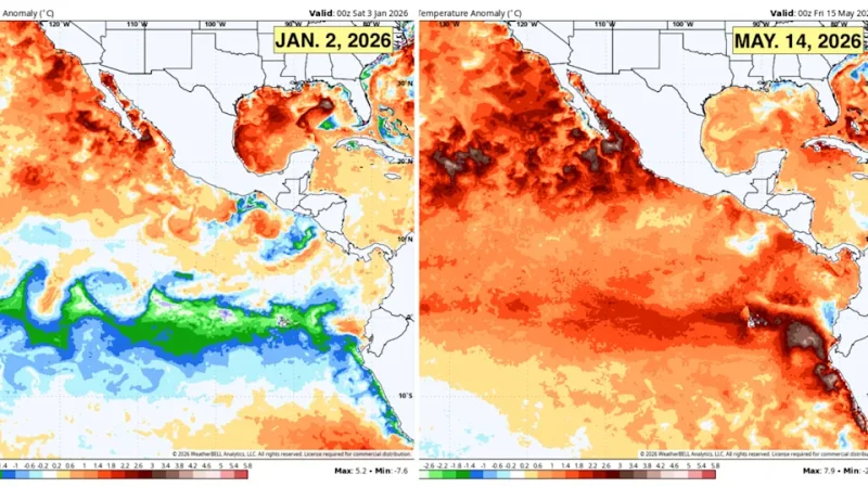
The central and eastern equatorial Pacific has been warming after months of cooler La Niña influence, pushing the climate system closer to El Niño conditions. Federal forecasters now give El Niño an 82% chance of developing during the May-to-July period and a 96% chance of continuing through December 2026 to February 2027.
That marks a notable shift from earlier outlooks that had left more room for neutral conditions through summer. The change reflects warmer sea-surface temperatures in key Pacific monitoring zones and model guidance that increasingly points toward a sustained warm phase of the El Niño–Southern Oscillation.
The official alert does not mean El Niño has already fully formed. For the pattern to be declared, the ocean warming must be strong enough and persistent enough to influence the atmosphere above it. That coupling between ocean and atmosphere is what allows El Niño to reshape weather patterns far beyond the tropical Pacific.
Why The El Niño Weather Pattern Matters
El Niño is the warm phase of the El Niño–Southern Oscillation, a recurring climate pattern that changes sea-surface temperatures, trade winds and storm tracks across the Pacific. Its effects vary by region and season, but stronger events can alter rainfall, drought patterns and temperature extremes across several continents.
In the United States, El Niño often increases the odds of wetter conditions across parts of the southern tier during fall and winter. It can also tilt parts of the northern United States toward warmer winter conditions, though local outcomes depend on other atmospheric patterns.
The pattern can also influence hurricane activity. El Niño tends to increase wind shear over parts of the Atlantic Basin, which can make it harder for tropical storms and hurricanes to organize. At the same time, it can support more activity in the eastern Pacific. Those tendencies are not guarantees, especially when ocean temperatures, regional pressure patterns and short-term weather systems push in different directions.
Super El Niño Talk Comes With Important Caveats
Some long-range model guidance has raised the possibility of a strong or even “super” El Niño later in 2026. That phrase usually refers to an exceptionally intense warm event in the tropical Pacific, similar in broad category to historic episodes that have produced major global climate disruptions.

The current outlook supports taking that possibility seriously, but not treating it as settled. Federal forecasters say there is still substantial uncertainty over peak strength, and no single strength category dominates the official probabilities. In other words, El Niño now appears likely, but whether it becomes moderate, strong or unusually intense remains an open question.
That caution matters because strong ocean warming alone does not automatically produce the same impacts everywhere. The atmosphere must respond in a way that reinforces the event, and regional weather can still vary sharply. A powerful El Niño raises the odds of certain outcomes; it does not script the season in advance.
Global Weather Impacts Could Build Into Winter
The greatest global effects would likely emerge if El Niño strengthens through late 2026 and persists into the Northern Hemisphere winter. Historically, significant events have been associated with flooding in some regions, drought in others, shifts in monsoon behavior, marine heat stress and changes in crop conditions.
Parts of South America can see heavier rainfall, while areas of Australia and Southeast Asia may face higher drought and heat risk during some El Niño episodes. In North America, winter storm tracks often become more active across parts of the southern United States, while Canada and the northern U.S. may experience milder conditions in some areas.
The humanitarian and economic stakes rise when El Niño develops on top of already warm global temperatures. Even when the pattern is natural, its impacts now unfold in a climate system that has retained more heat, increasing concern about compound events such as heat waves, water shortages, wildfire risk and food-production stress.
What NOAA Weather Outlooks Will Clarify Next
The next several monthly updates will be important because forecasters will be watching whether the atmosphere locks in with the warming Pacific. Key signs include weakening trade winds, shifting tropical thunderstorms and continued warming in the Niño 3.4 region, the benchmark zone used in many El Niño assessments.
Seasonal outlooks will also become more useful as summer turns to fall. At that point, forecasters should have a clearer view of how the developing pattern may affect U.S. winter temperatures, precipitation and drought risk.
For now, the message is measured but significant: El Niño 2026 is no longer a distant possibility. The odds have risen enough that emergency planners, agricultural interests, energy markets and coastal communities will be watching the Pacific closely. The central question is not whether the pattern can influence global weather, but how strong it becomes and where its effects land hardest.