A developing El Niño weather pattern is moving back into focus as U.S. and global forecasters warn that warming in the tropical Pacific is likely to influence storms, heat, rainfall and drought patterns through the rest of 2026. The shift is not yet being treated as a fully established event, but the latest outlooks show El Niño is likely to emerge soon and could persist through the Northern Hemisphere winter.
What Is The El Niño Weather Pattern?
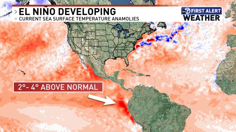
El Niño is the warm phase of the El Niño-Southern Oscillation, a recurring climate pattern centered in the tropical Pacific Ocean. During El Niño, sea surface temperatures in parts of the central and eastern equatorial Pacific become warmer than average, changing the flow of heat and moisture through the atmosphere.
Those ocean changes can alter the jet stream, tropical rainfall belts and storm tracks far from the Pacific. That is why El Niño can affect weather in the United States, Canada, Australia, Asia, Africa and Latin America even though the strongest ocean signal begins near the equator.
El Niño does not produce the same weather everywhere every time. Its impacts depend on strength, timing, duration and interaction with other climate drivers, including long-term warming, regional ocean temperatures and seasonal patterns already in place.
Forecasters Say El Niño Is Likely To Emerge Soon
The latest U.S. climate outlook shows El Niño is likely to develop between May and July 2026, with a much stronger chance that it continues through winter. The tropical Pacific has been moving away from the weak La Niña conditions seen earlier in the year and toward warmer sea surface temperatures.
That transition matters because spring is often a difficult time for long-range climate forecasting. The atmosphere and ocean can shift quickly during this period, creating what forecasters call a predictability barrier. Even so, the current forecast confidence is unusually strong compared with earlier 2026 outlooks.
The practical message is that weather-sensitive sectors should prepare for El Niño influence rather than wait for a formal declaration. Agriculture, water management, energy markets, disaster planning and insurance all watch ENSO closely because it can tilt the odds toward certain hazards months in advance.
Atlantic Hurricane Forecast Turns Quieter
One of the clearest near-term effects involves the 2026 Atlantic hurricane season, which begins June 1 and runs through November 30. Federal forecasters expect a below-normal season, with 8 to 14 named storms, 3 to 6 hurricanes and 1 to 3 major hurricanes.
El Niño tends to suppress Atlantic hurricanes by increasing wind shear, which can tear apart developing storms or prevent them from organizing. It can also promote atmospheric sinking and drier air across parts of the tropical Atlantic, making it harder for storms to intensify.

That does not mean coastal risk disappears. A below-normal season can still produce a destructive landfall if even one storm reaches a vulnerable area. Hurricane Andrew in 1992 remains a reminder that low storm counts do not equal low danger for communities in the path of a major system.
Pacific Storm Risk Could Increase
El Niño often has the opposite effect in parts of the eastern and central Pacific, where warmer water and more favorable atmospheric conditions can support more tropical activity. That means Mexico’s Pacific coast, Hawaii and parts of the broader Pacific basin may receive closer attention if the pattern strengthens.
The same broad climate shift can also influence rainfall. In some regions, El Niño raises the odds of heavy rain and flooding. In others, it increases the risk of drought, heat stress or wildfire conditions. Australia, Indonesia and parts of Southeast Asia often watch El Niño for drying signals, while parts of the southern United States can see wetter conditions during winter.
Those are tendencies, not guarantees. Local outcomes can diverge sharply from the textbook pattern, especially when other climate factors compete with the Pacific signal.
How El Niño Affects The United States
In the U.S., El Niño’s strongest seasonal influence typically appears in fall and winter. A classic pattern often brings wetter conditions to parts of the South, including California, the Southwest, the Gulf Coast and Florida, while parts of the northern tier may trend warmer than average.
The Pacific Northwest and northern Rockies can face reduced snowpack during some El Niño winters, which matters for water supply, hydropower and wildfire risk the following year. The southern storm track can become more active, raising the chance of flooding in areas already vulnerable to heavy rain.
Summer impacts are usually less straightforward. Heat waves, severe thunderstorms, wildfire behavior and drought conditions depend on regional weather setups as much as ENSO. Still, a developing El Niño can influence background conditions that shape seasonal risk.
Why This El Niño Matters Now
The developing pattern is arriving in a world already running warmer because of climate change. El Niño events can temporarily boost global average temperatures by moving more ocean heat into the atmosphere. That can increase the chance of record warmth, marine heat waves and weather extremes in some regions.
Forecasters are also watching whether the event becomes moderate, strong or very strong. A stronger El Niño would raise confidence in certain global impacts, though it would not make every regional forecast certain.
For now, the key point is timing. The Pacific is shifting just as hurricane season begins, farmers make growing-season decisions and governments prepare for summer and winter hazards. The El Niño weather pattern is not a single storm, but it can reshape the background climate that helps determine where the next major weather risks emerge.