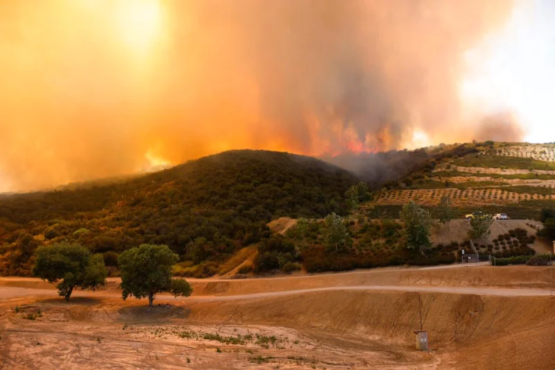
The Sandy Fire in Simi Valley remained an active threat Thursday after burning more than 2,100 acres in Ventura County, destroying at least one home and keeping thousands of residents under evacuation orders near the Los Angeles County line.
Fire officials listed the wildfire at 2,115 acres and 22% containment in the latest public incident update, with the cause still under investigation. The blaze began late Monday morning off Sandy Avenue in Simi Valley, a city in Ventura County about 30 miles northwest of Los Angeles, and quickly spread through dry brush under gusty winds.
Sandy Fire Map Shows Evacuations Across Simi Valley And Nearby Canyons
Evacuation orders remained in place for several Simi Valley zones and nearby canyon communities, including areas around Bell Canyon, Burro Flats and parts of the city’s eastern and southern edges. Warnings also extended into parts of Ventura and Los Angeles counties, including areas near Box Canyon and communities close to the county line.
An evacuation order means residents must leave immediately because of a direct threat to life. An evacuation warning means people should be ready to leave, especially those who need extra time, have medical needs, or are moving pets and livestock.
For residents searching for a Sandy Fire map or fire near Simi Valley, the key areas of concern have been the hills and neighborhoods south and southeast of the ignition point near Sandy Avenue. Fire perimeters can shift as mapping improves, and officials have cautioned that mapped fire boundaries do not automatically mean every structure inside the line has been damaged.
Firefighters Slow Growth After Wind-Driven Runs
The fire’s early growth was driven by dry vegetation, steep terrain and winds that pushed flames toward neighborhoods. Federal fire managers described the incident as burning in brush and grass with uphill and wind-driven runs, while also noting threats to homes, infrastructure, roads and trails.
Crews have used aircraft, engines and hand crews to build containment lines and cool hot spots around properties. Calmer periods helped firefighters make progress after the most dangerous wind conditions eased, but shifting wind, low humidity and rugged terrain continued to shape the response.
The 22% containment figure does not mean the fire is nearly out. It means a portion of the perimeter has control lines that fire managers believe can hold under expected conditions. Hot spots can still flare inside the burned area, and containment can change if weather worsens or flames cross lines.

At Least One Home Destroyed As Damage Checks Continue
At least one home has been confirmed destroyed in the Sandy Fire. Damage assessments were still continuing, and officials had not released a final structure-loss total as of the latest updates.
The human toll has extended beyond property damage. Thousands of residents were ordered or urged to leave, schools in the Simi Valley area were affected, and smoke created air-quality concerns across nearby neighborhoods. Emergency shelter was made available at Rancho Santa Susana Community Park, while small-animal and large-animal shelters were opened for residents evacuating with pets, horses or livestock.
Road closures have included portions of Bell Canyon Road, Katherine Road, Clear Springs Road, Oak Knolls Road, Crinklaw Lane and Santa Susana Pass Road. Drivers have been urged to avoid fire zones so engines, water tenders, ambulances and evacuation traffic can move safely.
Why The Simi Valley Fire Matters Beyond Ventura County
The Sandy Fire is burning in a region with a long and dangerous wildfire history. Simi Valley sits near rugged open space, canyon roads and wildland-urban interface neighborhoods where homes back up to dry hillsides. Those conditions can make even a relatively small ignition dangerous when winds accelerate flames toward developed areas.
The fire also raised concern because of its proximity to the Santa Susana Field Laboratory area. Air-quality monitoring equipment was deployed around the fire perimeter to establish readings and help officials assess smoke and air conditions. The latest incident update said the fire had not crossed into the Field Laboratory property.
That monitoring is significant because public concern around smoke is not limited to visible flames. Wildfire smoke can affect people miles from the fire line, especially children, older adults and anyone with asthma, heart disease or other respiratory conditions.
California Fires Add Pressure Early In The Season
The Sandy Fire is one of several active California fires drawing firefighting resources this week. Southern California has also faced other significant incidents, including fires in Riverside County and on Santa Rosa Island, while national fire managers listed multiple uncontained large fires across the region.
The timing underscores how California’s fire risk is no longer confined to the hottest months of late summer and fall. Dry fuels, wind events and expanding development near open space can create dangerous conditions well before peak fire season.
For Simi Valley residents, the most important next steps are official evacuation changes, containment growth, damage assessments and weather shifts. Residents under orders should not return until the order is lifted. Those under warnings should keep vehicles fueled, phones charged, medications packed and animals ready to move if conditions change.