A late-season storm is keeping parts of Colorado and Wyoming under winter alerts Tuesday, with heavy, wet snow, strong winds and slick mountain roads creating hazardous travel conditions well into the second half of May.
The most serious snow impacts are centered in the central Rockies, where higher elevations in Colorado and southeastern Wyoming face additional accumulation, drifting snow and freezing temperatures. Farther west, Interstate 5 in California is not under a broad snow closure, but high wind advisories remain in effect along several stretches, including the Grapevine, where travel is discouraged for campers, trailers and permit loads.
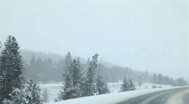
Colorado And Wyoming Face Heavy, Wet Snow
Winter storm warnings and advisories remain the main concern across higher terrain in Colorado and Wyoming, where the storm has delivered a sharp return to winter after a warmer spring pattern.
The snow is expected to be wet and heavy, making it more disruptive than a lighter, powdery event. That matters for tree limbs, power lines and road surfaces, especially in areas where leaves have already emerged and infrastructure is not being treated like it would be during peak winter.
In southeastern Wyoming, north to northeast winds are adding another travel hazard, with gusts strong enough to cause drifting snow and reduced visibility. In Colorado, mountain roads, foothill routes and elevated stretches near the Palmer Divide are vulnerable to icy and slushy spots, particularly on bridges and overpasses.
I-5 Snow And Wind Closure Concerns Focus On High Winds
Searches for an I-5 snow and wind closure surged as the broader Western storm system raised travel concerns, but the latest publicly listed restrictions show wind, not snow, as the main issue on Interstate 5 in California.
A high wind advisory is in effect along parts of the route, including the Grapevine north of Los Angeles and stretches through the Central Valley. Travel is not recommended for campers, trailers or permit loads in those advisory zones.
That distinction is important: a wind advisory can create dangerous driving for high-profile vehicles even when the pavement is dry and skies are clear. Sudden gusts can push trailers across lanes, make steering difficult and increase rollover risk. For regular passenger vehicles, conditions may remain passable, but drivers should still use caution in exposed sections.
No broad I-5 snow closure is listed for northern California or the Grapevine in the latest road status, though conditions can change quickly during spring storms.
Mountain Roads Remain The Highest-Risk Travel Zones
The most difficult travel is expected on higher-elevation routes in Colorado and Wyoming rather than on lower-elevation interstates farther west. Heavy snow can quickly reduce traction, and late-season storms often catch drivers off guard because many have already shifted out of winter travel routines.
The biggest risks include:
-
Slushy or icy mountain passes
-
Reduced visibility in blowing snow
-
Fallen branches from heavy, wet accumulation
-
Power interruptions in tree-lined areas
-
Dangerous crosswinds for trailers and trucks

Interstate 80 in Wyoming and Interstate 70 in Colorado are the corridors most likely to see winter travel impacts when snow bands and strong winds overlap. Even when closures are not in place, chain laws, traction rules or temporary restrictions can develop with little warning.
Why This May Storm Is So Disruptive
Late-season snow is not unusual in the Rockies, but this storm stands out because of timing, moisture content and wind. By mid-May, lower elevations are often dealing with spring thunderstorms, warm afternoons and active construction season. A heavy snow event at this point can create a different set of problems than a January storm.
Wet snow weighs down trees more efficiently, especially after spring growth begins. Roads can also alternate between wet, slushy and icy depending on elevation, shade and temperature. That creates rapidly changing driving conditions over short distances.
The storm is also part of a broader pattern bringing sharp contrasts across the country. While the Rockies deal with winter weather, parts of the Plains and Midwest are facing severe thunderstorm risks, and sections of the eastern United States are seeing much warmer conditions.
What Drivers Should Check Before Leaving
Travelers heading into Colorado, Wyoming or across wind-prone sections of I-5 should check official road conditions before departure and again during the trip. Spring travel decisions should not rely only on the forecast at a starting point because conditions can deteriorate at higher elevations.
Drivers crossing mountain passes should carry winter gear even in May, including warm clothing, water, food, a charged phone, a scraper and extra time. Truckers, RV drivers and anyone towing should pay close attention to wind advisories, which can be just as consequential as snow alerts for high-profile vehicles.
Air travelers should also monitor airport updates in Denver and nearby regional airports because spring snow can cause deicing delays, reduced visibility and schedule disruptions even when runways remain open.
Cold Air Lingers After The Snow
The storm’s final impacts will not end as soon as the snow tapers. Overnight lows in parts of Wyoming and Colorado are expected to fall below freezing, raising the risk of refreezing on untreated roads and creating concerns for plants, livestock and outdoor plumbing.
Conditions should gradually improve as the system moves away, but the immediate hazards remain travel-related: snow in the Rockies, wind on exposed highways and icy spots where temperatures drop after sunset. For drivers, the safest approach is to treat this as a winter storm in the mountains and a high-wind event on vulnerable interstate stretches, even though the calendar says May.