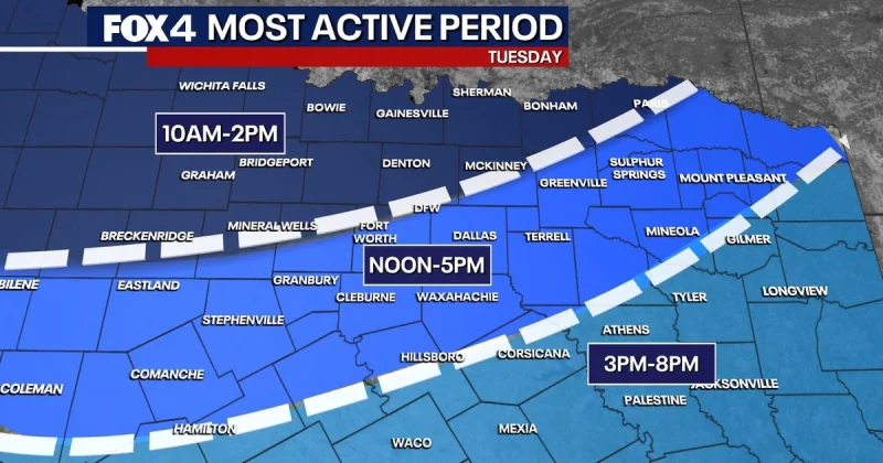
A cold front is pushing a line of showers and thunderstorms into North Texas on Tuesday, and the setup carries the risk of damaging winds and large hail as the day goes on. The best rain chances are expected Tuesday, when thunderstorms and locally heavy rain spread across the region.
Tuesday morning should start muggy and overcast, with chances for showers and storms increasing by Tuesday afternoon. The greatest hail threat is southwest of the DFW Metroplex, while the wider weather pattern brings the strongest chance for rain and storms to North Texas during the day.
The system does not move out quickly. After Tuesday, the front stalls to the south and additional disturbances move overhead through the rest of the week, keeping scattered showers and storms possible each day. That means the wet stretch will not be a one-day event, but a multi-day pattern that stays active into the weekend.
Wednesday brings another concern: isolated flooding. All of North Texas is expected to receive at least 1 inch of rain Wednesday through Friday, with rain chances ranging from 60% to 90% across the period. For the Dallas-Fort Worth area, the greatest rain threat is expected between noon and 6 p.m. Thursday, when heavier downpours could make travel slower and drainage issues more likely.
The unsettled pattern is being driven by the cold front and the disturbances that follow it, according to the National Weather Service and the FOX 4 Weather Team. Their forecast keeps the region in a cycle of showers and storms through the weekend, with no clean break in sight once the front arrives. For anyone watching Dallas weather this week, the answer is clear: Tuesday starts the active stretch, and the rain risk stays elevated well beyond that.