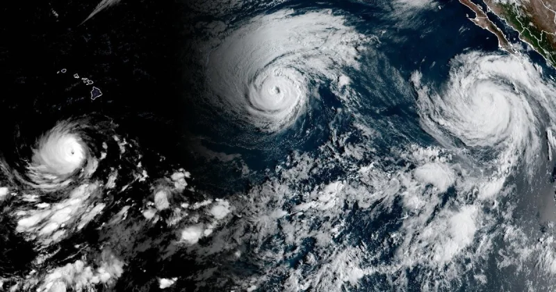
NASA’s EPIC camera on DSCOVR captured something rare on September 1: three tropical cyclones spinning at once in the Pacific. Lowell, Karina and Marie were all active in the same frame, and Lowell would become the strongest of the group, reaching category 5 strength for several hours the next day.
The image, taken at 1:14 p.m. Pacific Daylight Time, showed Marie still as a tropical storm and strengthening as it moved northwest. Karina was close behind, reaching category 4 strength around the same time Lowell hit category 5. For a basin already near the peak of hurricane season, the lineup was a sharp reminder of how quickly the Pacific can turn busy.
That is what makes the numbers matter. As of September 3, the Northeast Pacific had produced 15 named storms and six hurricanes, with an accumulated cyclone energy index of 130. The Atlantic, by contrast, had produced five named storms and no hurricanes, with ACE at 4.4. In one basin, storm energy was running far above normal. In the other, the season had barely found its footing.
NASA’s image also captured the broad band of clouds and thunderstorms tied to the Intertropical Convergence Zone south of the storms, underscoring the weather setup feeding the Pacific system. The contrast with the Atlantic was even starker because Tropical Storm Edouard had already made landfall there, bringing torrential rain and strong winds that downed trees and power lines, but little else was building behind it.
The mismatch is not accidental. El Niño has been associated with above-normal hurricane activity in the eastern and central Pacific and below-normal activity in the Atlantic, and the early September snapshot fit that pattern closely. It also showed something more unusual: category 4 and category 5 hurricanes active at the same time in the same region, a sign that the basin was not just active but unusually efficient at turning warm water into power.
Lowell’s peak may have been brief, but the image placed it inside a broader surge that is hard to miss. The open question now is not whether the Pacific was active — it plainly was — but how long Lowell, Karina and Marie would keep their strength and whether any of them would turn toward land as the season moved on.