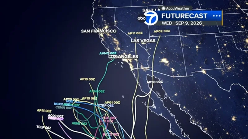
Tropical Storm Marie was upgraded to a hurricane on Wednesday, and the shift put Southern California beach weather on alert for Labor Day weekend. Marie was moving northbound earlier in the day, but forecast tracks still left the storm’s exact path uncertain.
That uncertainty is why the storm is drawing attention now. The National Weather Service said Tuesday that there is a high chance of large waves and strong rip currents for Labor Day beachgoers, and experts said there is a moderate chance of impactful coastal flooding for south-facing shores if Marie moves closer.
If Marie nears the Southern California coast, it could bring rain, gusty winds and high surf to the holiday weekend. The National Weather Service also put the chance of light rain affecting holiday events at moderate, while the chance of moderate to heavy rain with flooding and thunderstorms remained low.

The reason the forecast remains unsettled is in the model spread. Spaghetti models are forecast lines from computer models showing where a tropical system may go, and the more clustered those lines are, the higher the confidence in the forecast. Spread-out lines point to uncertainty, and that is what Marie is showing now. Some computer models place it close to the Southern California coast, but most of the plots keep it away.
Those model types are not built the same way. Dynamical models run for hours on a supercomputer to solve physical equations of motion. Statistical models lean on historical relationships between storm behavior and details such as location and date. Ensemble models combine forecasts from a collection of other models, which is why they can show both a range of outcomes and a general trend at the same time.
The Navy Global Environmental Model, run by the United States Navy's Fleet Numerical Meteorology and Oceanography Center, is one of the tools feeding that range. For now, the practical message is straightforward: Labor Day beachgoers should expect dangerous surf and rip currents, while the chance of rain or coastal flooding rises only if Hurricane Marie bends closer than most forecasts currently show.
The next question is whether those closer-in tracks keep gaining support or stay isolated. If the storm continues to drift offshore, the holiday threat will remain centered on the waterline rather than on widespread inland weather.