


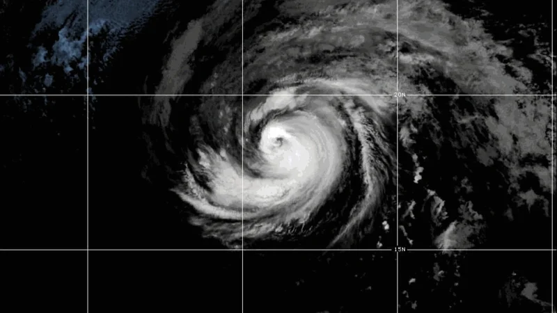
Hurricane Fausto entered the Central Pacific overnight as a Category 1 hurricane, and the early track now points it north of Hawaii later this week as it weakens. At 5 a.m. today, Fausto was 910 miles east of Hilo, moving west at 14 mph with maximum sustained winds of 85 mph.
That is why the Hurricane Fausto Hawaii Forecast is drawing attention now. The storm is still far enough away that it is not a close landfall threat, but it is already driving surf toward the islands, and the forecast path keeps Kauai as the only island inside the cone of uncertainty. In practical terms, that cone is the corridor forecasters use to show where the center could still pass; if the track stays near the middle of that corridor, the strongest impacts remain offshore. If it slips south, the forecast changes quickly for Hawaii.
Forecasters say the strongest winds and heaviest rainfall should remain north of the islands, but they also warn that a southward shift could bring stronger winds and possible heavy rain to Hawaii. For now, the most direct effects are already coastal. A high surf advisory for the south shores of all islands, with waves of 7 to 10 feet, is in effect until 6 p.m. today, and a separate advisory for the east shores of Oahu and the Big Island calls for waves of 10 to 14 feet until 6 p.m. Wednesday. A building east swell from Fausto is expected to begin hitting all exposed east-facing shores today.

The storm itself is also losing steam. The Central Pacific Hurricane Center says Fausto is expected to weaken as it approaches the vicinity of the Hawaiian Islands, with its convective organization likely to fall apart by the end of the forecast. The latest five-day map has it passing north of Hawaii on Wednesday as a weak tropical storm with 45 mph winds, then becoming a remnant low by Thursday as it moves beyond Kauai. That means the center of the storm is expected to stay out at sea, but the swell it throws off will still reach the islands.
For Oahu, today and Monday should stay mostly sunny and breezy, with temperatures in the 80s, before Tuesday and Wednesday turn more unsettled with numerous showers and winds of 15 to 25 mph. East shore surf is expected to rise as Fausto moves closer, then ease Wednesday as the system passes west. By Thursday and beyond, a drier and more stable breezy tradewind pattern is expected across Hawaii, suggesting the worst of the storm will have passed without bringing its core ashore.
The open question is not whether Fausto will brush the islands with rough surf. It already is. It is how far south the storm would have to drift before the forecast for Hawaii stops being a surf story and starts becoming a wind-and-rain story, and for now forecasters say that threshold still looks unlikely to be crossed.
