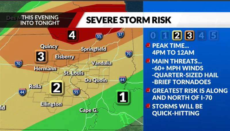
Strong storms are expected to move into the St. Louis area Thursday evening, with the Metro St. Louis area likely to fall in the storm path between 6 p.m. and 10 p.m. The most severe weather is expected to stay focused farther north, while the rest of the region braces for quick-hitting storms that could arrive after a hot day.
That timing matters because Thursday is expected to be punishingly warm, with temperatures in the mid-90s and a heat index that could top 105 before the storms arrive. A weather radar check later in the day will matter for anyone planning to be out Thursday night, especially across the metro and points north.

The northern portion of the viewing area is under a Level 3 out of 5 risk for severe storms Thursday, while the rest of the region is in a Level 2 out of 5 risk. Communities along and north of the Interstate 70 corridor are likely to see more severe weather than places to the south, and wind is expected to be the main threat Thursday night.
Storms are expected to develop quickly in the late afternoon, then spread across the area in bands rather than linger in one place. They should reach the northwesternmost part of the viewing area between 4 p.m. and 8 p.m., move into southeast areas, including Metro St. Louis, between 6 p.m. and 10 p.m., and reach the southeastern parts of the region between 8 p.m. and midnight. Any one spot could see storms for only 60 to 90 minutes.
That leaves a narrow window for the strongest weather, but also a messy one for commuters, school events and evening plans. The heat may ease somewhat before storms arrive as wind helps break up the humidity and extreme feel of the day, yet the same wind is also the chief hazard once the storms move through. What remains unclear is whether watches or warnings will be issued later Thursday; for now, the most specific risk is the timing, and the most exposed communities are those along and north of Interstate 70.