Heavy downpours are set to keep a flooding risk alive almost every day this week across Central Indiana, and the most dangerous stretch is expected late Thursday into Friday, when storms could bring damaging winds, hail and flash flooding. The immediate concern today is where the rain has already loaded the ground and where more is coming first.
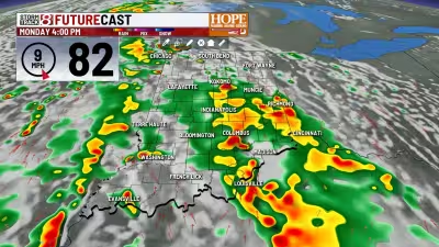
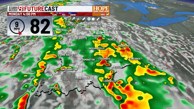
South and west of Indianapolis face the greatest chance of heavy, potentially flooding rainfall on June 8, 2026, while northwestern counties and east-central areas from Lafayette southwest to the I-74 corridor west are already waterlogged. Those spots picked up 2 to 4+ inches of rain over the weekend, leaving soils with little room left for more water to soak in.
Scattered to widespread showers and thunderstorms are expected through the day Monday, with coverage and intensity increasing in the afternoon. Rain will continue into tonight before gradually diminishing as the trough pushes into Ohio overnight, though a few light showers could linger across the eastern part of the area into Tuesday morning.

That short break may not last long. Temperatures are expected to rebound into the upper 80s Tuesday afternoon under clearing skies, then Wednesday turns warm and sticky again with southwest flow, high humidity and enough afternoon instability to spark isolated showers and storms into the evening. Some areas should improve significantly by Tuesday afternoon, but the broader forecast still keeps flooding risk elevated almost every day this week.
The next major round comes Thursday, when hot, unstable air with dew points in the upper 60s to low 70s and strong afternoon heating pushes temperatures into the upper 80s to low 90s. Late Thursday, a cold front will move through Central Indiana and could trigger storms capable of damaging straight-line winds and isolated large hail. Any storm bands that train over the same neighborhoods would also raise the flash flood threat quickly.
The front is expected to clear southern Indiana late Friday night into Saturday morning, and that should finally start to settle the pattern down. A strong Canadian high is forecast to bring a sharp northwest wind shift Saturday, along with cooler, drier air, highs closer to average and humidity much lower. Until then, the region is heading into a week where the ground is already saturated in the worst-hit areas and the weather keeps finding ways to add more water.