The El Niño weather pattern is making a fast and powerful comeback in 2026. Climate scientists are now tracking what could become one of the strongest El Niño events in recorded history, with major implications for temperatures, rainfall, hurricanes, and drought across the globe. Here is what the latest data reveals.
What Is the El Niño Weather Pattern
The El Niño weather pattern refers to a warming of ocean surface temperatures above average in the central and eastern tropical Pacific Ocean. It is part of the ENSO cycle, a recurring oscillation that directly affects rainfall distribution in the tropics and has a strong influence on weather across the United States and other parts of the world.
During El Niño, the low-level surface winds that normally blow from east to west along the equator weaken or, in some cases, reverse direction entirely. This shift reorganizes the global atmospheric circulation and redirects storm tracks, moisture flow, and temperature patterns around the world.
El Niño 2026 Is Already Forming — Faster Than Expected
As of mid-May 2026, the equatorial Pacific is rapidly transitioning into El Niño conditions. Weekly sea surface temperature values have surged well above the threshold, with the last three weekly measurements firmly reaching plus 0.9°C in the critical Niño3.4 region.
The latest forecast assigns a 98% probability to El Niño during May through July 2026, with forecast probabilities remaining exceptionally high at 97–98% throughout the rest of the year and into early 2027. Climate scientists describe the speed of this transition as striking and unusually rapid.
Could This Become a Super El Niño Event
Latest analysis reveals a significant subsurface Kelvin wave currently surfacing in the eastern Pacific, signaling the onset of what forecasters are now calling a Super El Niño event. The intensifying warm phase is expected to trigger a reorganization of the global atmospheric circulation.

The odds of a Super El Niño between November 2026 and January 2027 have increased to approximately a 1-in-3 chance, up from a 1-in-4 chance the previous month. A stronger El Niño is more likely if changes in the atmosphere continue to sync with changes in the tropical Pacific Ocean this summer.
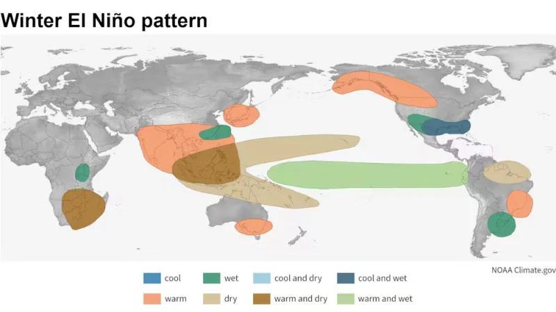
El Niño Weather Impact on the United States This Summer
Above-normal temperatures are forecast for Summer 2026 across the northwestern, western, and southern United States. At the same time, a corridor of increased rainfall is expected over the northern and eastern United States, while less rainfall than normal is projected over the southern U.S. and Florida.
The El Niño pattern could also bring more rain than normal to the Colorado River Basin, offering some relief to drought-stricken regions in the West. An early start to El Niño can increase moisture from the southern Plains to the East Coast during summer and fall.
El Niño's Effect on the 2026 Atlantic Hurricane Season
During the summer, El Niño's warm water can fuel hurricanes in the central and eastern Pacific Ocean, while simultaneously hindering hurricane formation in the Atlantic Basin. This is one of the most significant and consistently documented effects of the El Niño weather pattern.
The latest long-range precipitation forecast for the 2026 hurricane season shows well below-normal rainfall in the main Atlantic development region, indicating suppressed storm activity and a lower chance of a large number of named storms forming this season.
Global Temperature Outlook Under El Niño 2026
Forecasts indicate nearly global dominance of above-normal land surface temperatures in the coming three-month period, with the signal particularly strong over southern North America, Central America, the Caribbean, Europe, and Northern Africa.
Scientists note that if the El Niño develops as expected, it would push up global temperature estimates for 2026 and make 2027 very likely to become the warmest year on record. The El Niño weather pattern, amplified by ongoing background climate warming, is setting the stage for a historically significant atmospheric event.