Severe weather that brought tornado watches, tornado warnings and damaging thunderstorms to parts of Iowa and Nebraska has eased Tuesday, leaving behind cooler temperatures, gusty winds and lingering flooding concerns. The shift follows an active stretch of storms that kept residents in Des Moines, Omaha, Lincoln and surrounding communities watching radar closely as rotating storms moved across the central Plains.
Severe Weather Threat Eases Across Iowa And Nebraska
The immediate risk for organized severe storms has moved away from central Iowa and eastern Nebraska, giving the region a quieter but noticeably cooler day. Des Moines entered Tuesday under cloudy skies, with highs expected in the low 60s and breezy conditions replacing the unstable air that fueled earlier storms.
Omaha and Lincoln also moved into a cooler pattern, with morning temperatures in the 40s and afternoon highs generally near the lower 60s. The change is significant because it shows the main storm system has pushed east, reducing the near-term threat of tornadoes and widespread damaging winds in the Omaha-to-Des Moines corridor.
For residents who spent the weekend and Monday checking severe thunderstorm watches, tornado radar and local warning alerts, the calmer setup offers a break. It does not end the need for caution, especially in places where heavy rain created flooding or where storm damage may still be assessed.
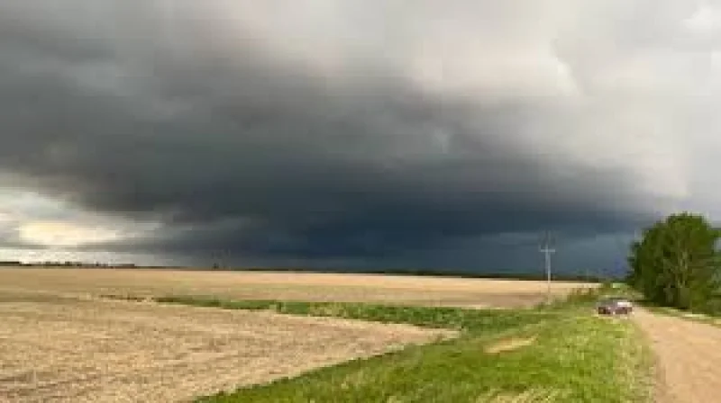
Tornado Watches And Warnings Drove Overnight Concern
The latest round of severe weather was part of a broader central Plains outbreak that produced supercell thunderstorms capable of large hail, damaging wind gusts and tornadoes. Parts of southeastern Nebraska and nearby states faced a higher-end severe weather risk Monday, with forecasters warning that strong tornadoes were possible where storms could remain isolated long enough to rotate.
Warnings during the outbreak prompted heightened concern around Lincoln, Omaha and rural parts of Nebraska. One of the more serious storm reports involved a large tornado near Palmer, Nebraska, where early information indicated structural damage. Details about injuries and the full extent of the damage were still developing early Tuesday, pending official review and local emergency updates.
The outbreak also drew attention across Iowa, where western and central counties watched storms intensify and move east. In Des Moines, the main concern shifted from the initial hail threat to damaging winds as storms organized into lines later in the event.
Storm Prediction Center Shifts Main Risk Away From The Region
By Tuesday morning, the national severe weather focus had shifted south and east, away from Iowa and Nebraska. The main concern extended from parts of the southern Plains into the lower Mississippi Valley, the Ohio Valley and the lower Great Lakes, where damaging winds and hail were the primary threats.
That shift matters for Iowa and Nebraska because it lowers the immediate tornado risk in cities such as Des Moines, Omaha and Lincoln. The atmosphere behind the system is cooler and more stable, making widespread severe storm development less likely through midweek.

Still, the region remains in an unsettled spring pattern. Rain chances return later in the week, especially Thursday into Friday, and scattered showers may continue into the weekend. At this stage, the next round appears more like a cool, rainy pattern than a repeat of the high-end tornado setup, though forecasts can change as new data comes in.
Flooding Remains A Concern After Heavy Rain
Even as the tornado threat fades, flooding remains a hazard in parts of the broader region. Heavy rainfall from repeated storms can overwhelm low-lying roads, small streams, drainage areas and agricultural land. Flooding often becomes most dangerous after the strongest storms have already passed, when drivers may encounter water-covered roads in darkness or low visibility.
Northwest Missouri and nearby areas have faced flood warnings after several inches of rain fell in a short period. Rivers and smaller waterways in the region were running high, with moderate flooding possible in some locations before levels gradually fall.
The main public safety message remains simple: avoid flooded roads, do not drive around barricades and treat water-covered crossings as unsafe. Even shallow moving water can push vehicles off roads, and washed-out pavement may not be visible beneath the surface.
Des Moines, Omaha And Lincoln Weather Turns Cooler
The short-term forecast for Des Moines is cooler and mostly cloudy, with a few showers possible and highs struggling to rise much beyond the low 60s. Overnight temperatures will dip into the 40s, and patchy frost may be possible north of the city in colder spots.
Omaha weather follows a similar pattern, with breezy conditions, cool afternoons and more clouds than sun through midweek. Lincoln weather also stays cooler, with highs in the lower to middle 60s before rain chances increase later Thursday.
By the weekend, temperatures should begin to recover. Des Moines may climb back into the 70s by Saturday and upper 70s by Sunday, while Omaha and Lincoln could also warm closer to 80 degrees as the system exits and southerly flow returns.
What Residents Should Watch Next
The main severe weather episode has moved out of Iowa and Nebraska, but the next forecast checkpoints will come late Thursday and Friday as showers and thunderstorms return. Residents should continue monitoring official alerts, especially if later forecasts show stronger instability or renewed storm organization.
For now, the region is moving from tornado warning mode into cleanup, flood awareness and routine forecast monitoring. The most important change is that the highest-end severe threat has eased, while the lingering impacts of heavy rain, strong winds and possible tornado damage may take longer to fully assess.