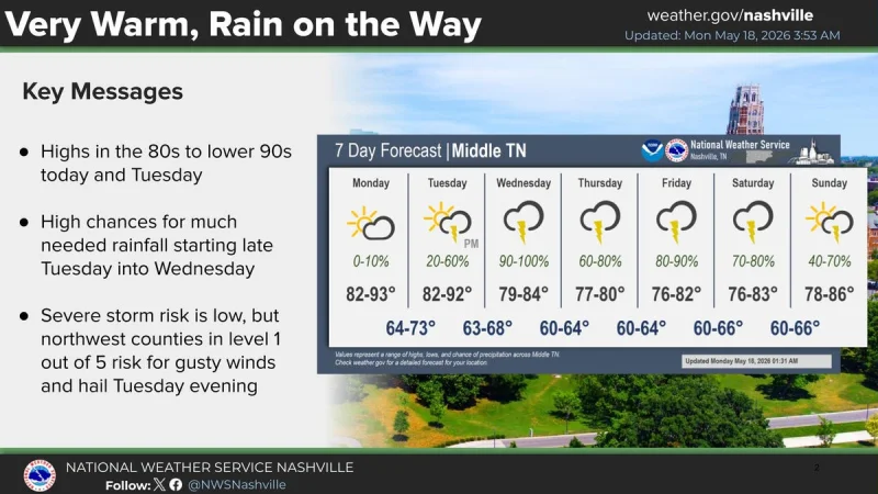
Nashville weather is turning wet after a hot, mostly sunny start to the week. The National Weather Service office in Nashville said showers and storms were expected to begin late Tuesday afternoon and evening, with the western half of the city included in a marginal risk for severe weather on May 19.
The forecast calls for a 30% chance of showers and thunderstorms after 4 p.m. on May 19, with a high around 92 and overnight lows around 67. Forecasters said the storms would be limited in duration, coverage and intensity, though damaging wind gusts and localized hail remained possible in the marginal risk area that stretched across a diagonal swath of Tennessee from the Alabama state line to the Kentucky state line in West Tennessee.
The weather service also said Tennessee was not looking at any tornado risk on May 19, and that storms should weaken as they move east. The more notable change comes on May 20, when the chance of rain jumps to 100% after 10 a.m., with a high near 83 and showers likely to continue into the evening. The latest forecast showed 1 to 2 inches of rain, with some 3+ inch amounts, from May 20 through the weekend.
That rainfall could be welcome. The forecast was framed as potentially helpful for drought relief in Nashville and Middle Tennessee, where the pattern has been dry enough that forecasters are hoping the incoming system delivers meaningful moisture. May 18 was expected to be sunny and hot, with a high near 92 and overnight lows around 73, before the atmosphere turns more unsettled.
After the strongest rain chance on May 20, the weather service said the severe weather threat also appeared low that day. Still, the rain is not expected to end quickly. Showers are likely on May 21 with a high near 79, followed by a 90% chance of showers and a thunderstorm possible on May 22 with a high near 81. The pattern stays active on May 23, when there is an 80% chance of showers and a thunderstorm possible with a high near 82, before easing somewhat on May 24 with a 50% chance of showers and thunderstorms and a high near 85.
Forecasters said the unsettled weather is favored to persist through the end of the week and into next weekend as the front stalls somewhere over the region and southerly flow continues to advect moisture into the area. In practical terms, that means Nashville weather may stay changeable through the Memorial Day weekend, with the best chance for soaking rain coming Tuesday and the main severe threat staying limited and localized rather than widespread.