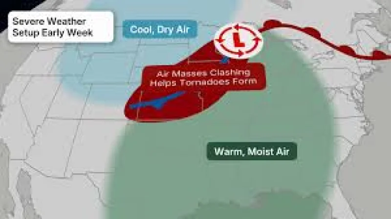
A severe Weather outbreak is possible across the Plains beginning Sunday, with the threat expanding from scattered storms Saturday into a wider, more dangerous setup early next week. The risk includes tornadoes, hail and damaging winds, with some of the strongest storms expected to form near a frontal boundary, a dryline and an area of low pressure.
Des Moines, Lincoln, Omaha, Chicago, Indianapolis and Sioux Falls are among the cities in the threat zone Saturday and Saturday night, when scattered supercell thunderstorms are possible overnight through the shaded area on the forecast map. Large to very large hail, gusts over 75 mph and a few strong tornadoes are possible as the storms fire up, and the most widespread threat appears to be in the dark orange and red areas that could see an outbreak of severe thunderstorms.
The timing matters because this is not shaping up as a one-night event. Storms could come in multiple rounds, first in the morning in the upper Midwest, then again in the afternoon and at night from the Plains to the upper Midwest. NOAA's Storm Prediction Center has also mentioned the potential for strong tornadoes by Sunday evening in the Central Plains and upper Midwest, underscoring how quickly the risk could escalate once storms begin to organize.
Farther south, especially in Oklahoma, the outlook is less active and may bring relatively few severe storms. But the dryline remains a concern there too, because storms that form along it could become supercells capable of hail, damaging winds and possibly a tornado. That leaves a sharp contrast across the region: some areas may see only isolated storms, while others brace for the kind of setup that can turn violent fast.

Monday may be the most widespread severe Weather day of the stretch, with a threat that could extend from Texas to Michigan. The area most likely to be hit includes Des Moines, Kansas City, Omaha and Wichita, and the hazards broaden to include strong to intense tornadoes, damaging winds, large to giant hail and flooding rain. NOAA's Storm Prediction Center said strong to intense tornadoes are possible in parts of the Central Plains by Monday evening and warned there may be a need to increase the threat in the coming hours.
The storm pattern does not end there. More severe thunderstorms are possible Tuesday ahead of the frontal system from parts of the Southern Plains to the mid-Mississippi and Ohio Valleys, possibly into the Great Lakes. By Wednesday and Thursday, scattered severe storms could return in parts of the South and may extend into parts of the East.
The forecast is being watched against a backdrop of already active severe Weather. On May 14, the Central Plains logged 39 wind reports and three large hail reports. On May 15, there were 52 wind reports and 30 large hail reports. Among the more notable reports was a gust to 84 mph in Seagraves, Texas, along with a couple of tennis ball-sized hail reports, or 2.50 inches in diameter, across Iowa.
That recent damage is why the next several days carry so much weight. The atmosphere has already shown it can produce strong winds and large hail, and the next round of storms is expected to be stronger and more widespread, with the potential to shift quickly from isolated severe cells to a larger outbreak. For people in the Plains and upper Midwest, the forecast is now a sequence of threats, not a single front passing through.
The clearest answer is that the risk rises through Sunday, peaks in reach on Monday, and remains active into midweek. What changes from day to day is not whether storms are possible, but how many places they can hit and how severe they may become.