


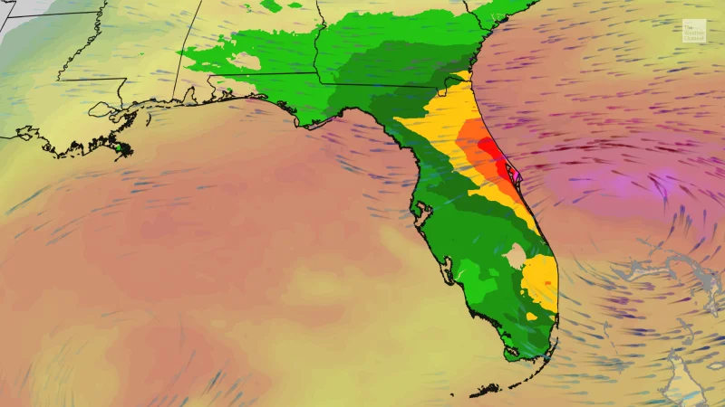
Florida is heading into a very wet late half of the week as a slow-moving low pressure system moves from the eastern Gulf across the peninsula and into the far western Atlantic. The heaviest rain is expected along Florida's East Coast, where flooding is likely to build from Wednesday through Friday and intensify into Saturday.
The forecast is why people are searching now: NOAA's Weather Prediction Center has issued level 3 out of 4 flood threats for parts of the Atlantic coast on Wednesday, Thursday and Friday, and the threat area shifts and expands slightly northward each day. The bull's-eye through Saturday is expected to land between Jacksonville and Port St. Lucie, where at least four inches of rain is anticipated and some communities could see more than a foot.

Showers and thunderstorms are expected to stay sporadic through Thursday, then increase in coverage and longevity into Friday as persistent onshore flow holds along Florida's Atlantic Coast. Winds aloft are expected to turn growing storms back toward the Atlantic, helping keep the heaviest rain pinned near the coast instead of letting it move away quickly.
That is what makes this round of Florida flooding stand out. The state is in the stretch that is supposed to be its dry season, from October through May, yet El Niño is likely to bring rainfall amounts more akin to the middle of thunderstorm season. In other words, the atmosphere is set up to produce repeated rounds of heavy rain when Florida usually expects something much quieter.
Computer models are converging on a low pressure system forming near the surface east of Florida by late Friday or early Saturday, which could help keep the rain machine running. The same pattern can also bring severe weather, including tornadoes, because the jet stream that feeds the rain also brings wind shear. For now, the immediate concern is simple: more rain is coming, and the hardest hit stretch is likely to be the East Coast corridor between Jacksonville and Port St. Lucie.