


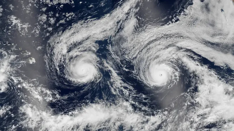
A satellite image showed Hurricane Madeline on the left and Hurricane Lester on the right as the two storms barreled toward Hawaii’s Big Island in 2016. The image, taken by Suomi NPP, captured a rare side-by-side approach that had forecasters watching one storm after the other.
That image is drawing attention now because it shows how close the pair came to the islands before both turned away. Madeline was the 14th named storm of the 2016 Pacific hurricane season, Lester the 13th, and the season would end tied for the sixth-most-active on record with 22 named storms.
By Aug. 30, Madeline had peaked as a Category 4 storm with winds around 130 mph, or 210 km/h, while Lester was still about 900 miles behind it on the same track. Madeline was just under 400 miles from the Big Island that day, close enough that the Central Pacific Hurricane Center later issued a hurricane warning for Hawaii and said Madeline would pass dangerously close to the island.

The uncertainty was real. Meteorologists could see the pair moving on similar paths toward Hawaii, but they could not know from the satellite view alone whether either would hit land. Madeline passed south of Hawaii on Aug. 31 after weakening to Category 1, while Lester briefly became a Category 4 storm on Sept. 1 before weakening to Category 3 and passing north of the Big Island two days later.
Lester came within around 130 miles of Honolulu before it turned sharply northward and petered out. Neither storm made landfall, yet both still brought high winds, heavy rainfall and strong surf across Hawaii. The image also shows another quirk of the moment: the Big Island is partly hidden on the left by sunglint, the reflected sunlight that can wash out part of a satellite view.
Hawaii sits in a corridor where most Pacific hurricanes form, but it usually avoids the worst of them because of high pressure to its east and strong eastward winds. In 2016, those steering patterns helped turn two hurricanes aside after they had made one of the closest double approaches the state had seen in years.