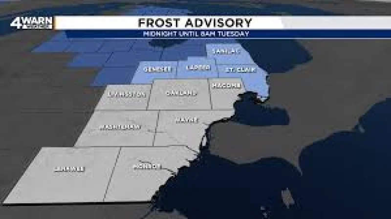
A Freeze Warning is in effect from midnight through 8 a.m. Tuesday for Sanilac, Genesee, Lapeer and St. Clair counties, where temperatures could fall to 32 degrees. Residents in those areas with sensitive outdoor plants should cover them or bring them indoors before the cold settles in overnight.
The timing matters because the advisory covers only part of Southeast Michigan while Metro Detroit stays somewhat milder, with skies mostly clear and temperatures falling to around 40 degrees there overnight. Colder locations farther north and west could slip into the 30s, but the sharpest frost risk is centered in the counties under the advisory.
Tuesday should start chilly and then turn pleasant and dry, with afternoon highs around 65 degrees. By Tuesday night, temperatures are expected to ease into the lower to mid-50s, setting up a warmer stretch that will be hard to miss after the overnight cold.

The split between nearby areas is the part that may catch people off guard. One part of Southeast Michigan is dealing with a Frost Advisory and near-freezing temperatures, while another will miss the worst of it by just enough to stay a little milder. That means the frost threat is not broad and uniform; it is focused, and for gardeners and anyone with tender plants, that difference is the whole story.
After the cold start, the trend turns steadily warmer. Highs are expected to reach the lower to mid-70s on Wednesday, though west winds could occasionally gust above 20 mph and a couple of sprinkles are possible that morning. Thursday should stay dry and mostly sunny with highs in the upper 60s, Friday looks mostly sunny near 68 degrees, and the weekend stays seasonably mild before temperatures climb back into the lower 70s by Sunday and Monday.
The immediate task is simple: protect plants before midnight if you are in the advisory counties. After that, the cold is brief, and the bigger shift is the warm-up that takes hold almost as soon as Tuesday gets going.