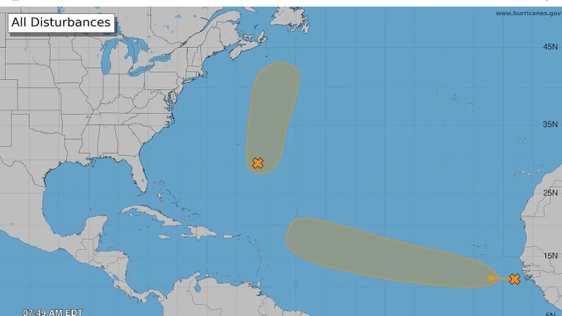
Invest 95L could strengthen into a tropical depression or storm in the Atlantic over the next couple of days, the National Hurricane Center said Sunday morning. Forecasters said the system was being watched alongside another disturbance, with the next named storm of the season set to be Dolly.
The latest advisory, issued at 8 a.m. on Aug. 24, put the low a few hundred miles east-southeast of Bermuda, where it was still showing signs of organization. It was moving northward and north-northeastward well northeast of Bermuda, and forecasters said the broad area of low pressure could become a short-lived tropical depression or storm during the next couple of days.
That is why the forecast is drawing attention now. Mid-August through mid-October is the busiest stretch of the Atlantic hurricane season, and systems that look disorganized one day can quickly gather enough structure to be classified as a tropical depression once winds and circulation become organized around a closed center. A tropical wave and associated area of low pressure that moved offshore of west Africa was also being tracked, with disorganized showers and thunderstorms and environmental conditions expected to be only marginally conducive for development.

Forecasters said that second system could form a tropical depression by the middle to latter portions of the week as it moves generally westward at 15 to 20 mph across the eastern and central tropical Atlantic. They also are watching four tropical waves, including two in the Caribbean, but the immediate focus remains on whether Invest 95L actually organizes fast enough to earn a name and, if it does, how much strength it keeps.
There is still a catch. Even with two disturbances on the board, forecasters said it is too early to tell whether Florida could feel any impacts. That leaves the state in the long view of the forecast rather than the short one: the Atlantic is active, the next several days matter, and the answer for Florida will depend on where the system goes after it tightens up, not just whether it develops at all.
For now, the most concrete expectation is that the window for change opens during the next couple of days and remains in play into the middle and latter portions of the week. If Invest 95L holds together, it could become one of the season's first named systems; if it does not, the broader Atlantic may still produce development elsewhere before the week is out.