


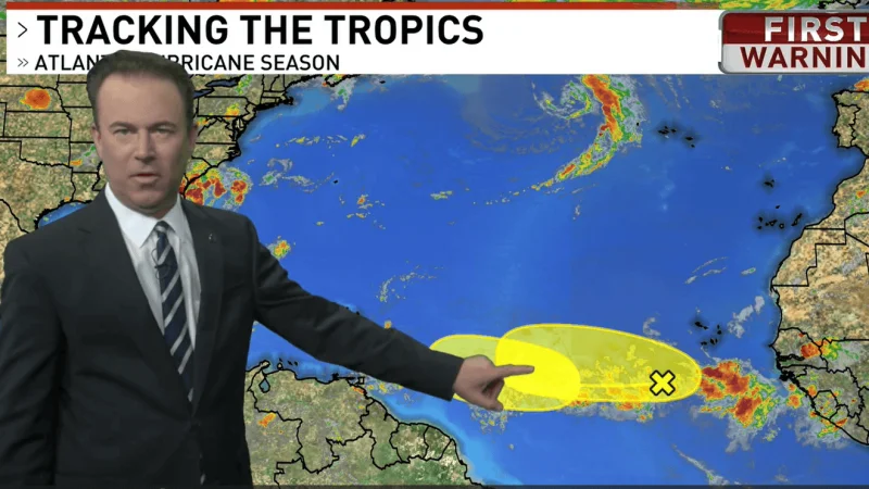
Two tropical waves are being watched over the Atlantic, and one now carries the better chance of becoming something more organized. A wave near the Cabo Verde Islands has only a slim chance of development and is expected to weaken as it moves toward the Lesser Antilles, while a second wave is forecast to move off the west coast of Africa with a 40% chance of development through the next seven days.
That 40% figure matters because it means forecasters see a real, but far from certain, path for the disturbance to gather enough spin, moisture and thunderstorm activity to tighten into a tropical depression. At that stage, the system would be a more defined center of low pressure rather than just a broad wave, and that could happen during the second half of next week as it moves across the eastern and central Atlantic.

For people watching weather closer to home, the same Atlantic setup is tied to a sticky summer pattern in Baton Rouge. The region is caught between two areas of high pressure, with an upper-level high over the desert southwest and the Bermuda high to the east, and that pattern is expected to deliver typical summer-like weather with pop up afternoon storms and slightly hotter temperatures.
The best chance for rain locally is on Monday and Tuesday, when scattered thunderstorms are most likely to break out during the afternoon, mainly south of the I-10/12 corridor. Farther inland, storm chances are lower and any activity should be isolated. Afternoon highs are expected near 90 degrees, and localized heavier storms are possible, especially for the coastal parishes.
After Monday and Tuesday, the forecast turns back toward mainly hot and dry weather through next weekend. That leaves the Atlantic disturbances as a separate but closely watched problem: one wave looks likely to fade, while the other keeps enough organization potential to stay on the radar as it crosses the eastern and central Atlantic.
