


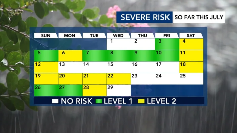
July has already produced nine days with a Level 2 severe-weather risk in the WRAL viewing area, and those days have brought nearly 160 reports of storm damage. That is a steady toll for a month that has also been unusually wet, with rain that has helped but has not kept repeated thunderstorm threats from turning destructive.
Residents in the WRAL viewing area are again watching the forecast because a Level 2 risk was in place for Tuesday afternoon and evening. NOAA's Storm Prediction Center, which issues severe-weather outlooks up to eight days ahead to gauge the chance of damaging thunderstorms, had already outlooked 18 of the 28 days so far in July for severe weather. Level 2 is not the highest threat, but it means scattered severe storm potential, and in July 2026 that level has repeatedly mattered in a way lower-risk days have not.

The numbers give that pattern some weight. Across those nine Level 2 days, the area averaged 18 storm reports per day, and only three of the days produced no damage at all. In other words, most Level 2 outlooks in July did not fade into nothing. They were often followed by real reports of wind, hail, or other storm damage, which is why the level has become a close watch point for people tracking the month’s weather.
That does not mean every outlook verified the same way. The broader month has been largely beneficial because it has been very wet, and rainfall has eased some dry concerns even as it has also raised the number of severe-weather threats. The friction is simple: a wet month can be welcome, yet the same storm systems that bring soaking rain can also produce damaging thunderstorms, and July has already shown both sides of that equation.
Tuesday carried that same uncertainty. Clusters of storms were being tracked coming in from the Ohio River Valley, and if one of those clusters arrived around midday, it would not be severe. Rain-cooled air left behind by that cluster could then limit the chance of severe storms later Tuesday, but that is not the same as removing the risk altogether. For now, the clearest answer is that July has already turned a scattered severe-weather outlook into a measurable damage tally, and Tuesday was another test of whether that pattern would continue.
