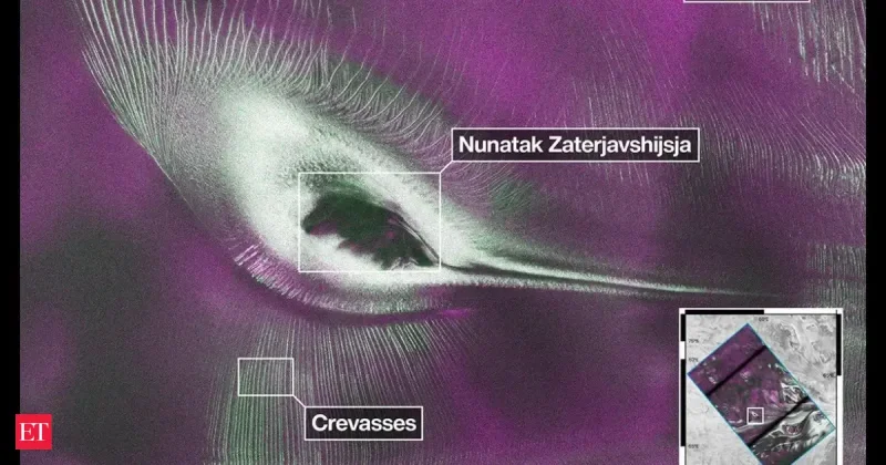
NISAR has turned up an Antarctic image that looks like a colorful hummingbird, but the shape is really a radar map of ice and rock in East Antarctica. The bird-like view came from the spacecraft’s radar instruments, and the data behind it started becoming public on July 20.
The image’s dark center is the top of Nunatak Zaterjavshijsja in East Antarctica. Its tail is a stream of ice flowing northeast to the ocean, while the feather-like streaks are crevasses cut as a glacier fractures the mountain’s surface and moves seaward. What looks like a bird is a record of motion: the radar is tracing how the ice is flowing, not photographing something flying overhead.

Seongsu Jeong, who produced the image at NASA's Jet Propulsion Laboratory, said the picture offers insight into how the glacier is moving. He also said radar can often see through snow and deep into the ice, which means NISAR can detect properties of Antarctic ice that optical imagery cannot show. That makes the image more than a curiosity. It is a demonstration of what the mission was built to do.
NISAR, short for NASA-ISRO Synthetic Aperture Radar, launched as a collaboration between NASA and ISRO. Last year, the director of NASA's Earth Science Division called it the most sophisticated radar ever built in a pre-launch briefing, and the claim is easier to understand now that the mission is beginning to open its data stream. With the radar observations now public, researchers everywhere can use them to study and protect the planet.
The odd part is that the image works on two levels at once. It is visually striking enough to read like a bird, but every part of it is grounded in terrain and ice physics. That gap between appearance and measurement is exactly why the public release matters: the pictures may pull people in, but the data will let scientists test what is happening beneath the Antarctic surface as mission teams continue rolling it out.