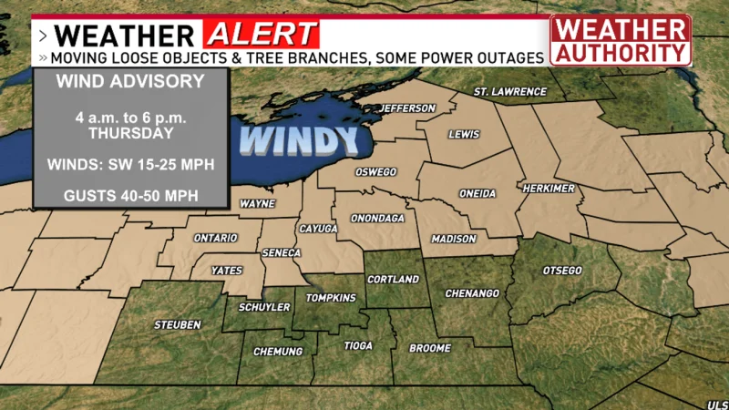
Wind advisories are set to take effect at 4 a.m. Thursday across most of CNY as a strong weather system pushes in from the west. The setup is expected to bring south and southwest winds, rain, and a period of severe weather before mid-morning.
That is why meteorologist Sam Postitch will be live on NBC3 from 4 a.m. to 7 a.m. Thursday, tracking the strongest gusts and any thunderstorms that turn severe. The overnight window matters because the most active period is expected between 4 a.m. and 9 a.m., right when people are heading into the day and the first round of storms could be strongest.
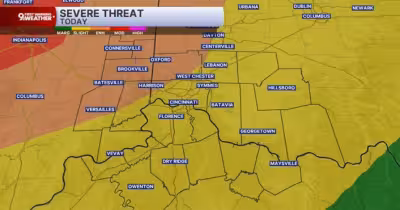
The wind threat is tied to a big pressure difference between low pressure to the west and a Bermuda high to the south and east, a setup that can drive strong winds and keep storms moving through quickly. Rain, heavier downpours, thunder, lightning and gustier winds are all in play, and some storms could bring tree and powerline damage with a few outages. Small hail and flash flood warnings are also possible, and a tornado warning cannot be ruled out.

Sam Postitch said there are real weather concerns as the overnight hours give way to sunrise Thursday, and he urged viewers to track the storms before focusing on the broader high winds. Most of CNY is under a marginal risk, which is similar to a 1 on a scale of 1 to 5, so the threat is not widespread but it is enough to cause trouble in the wrong spot. The warm front is expected to clear by around 9 a.m., and temperatures could climb near 80 once the sun comes out.
There may still be a couple more storms Thursday afternoon, but the bigger shift comes after that. Friday, Saturday and Sunday are expected to be quiet, which means the roughest stretch is concentrated into the overnight and early-morning hours Thursday.
For now, the question is not whether the weather will turn active. It already is. The question is which towns will take the hardest hit during that short window before the front moves out and calmer weather settles in for the weekend.