Illinois is back in storm season, and the National Weather Service is drawing a hard line between a tornado watch and a tornado warning as severe weather builds again this week. A watch means the conditions could produce tornadoes. A warning means a tornado has been spotted or picked up on radar, and people need to move fast.
That difference matters because severe weather is forecast to return on Tuesday, with more severe storms expected on Wednesday. The forecast includes heavy rain, flooding, hail, wind damage and more tornadoes, a reminder that the alert level can change quickly as a storm develops.
For people checking alerts on weather apps or local news, the first step during a tornado watch is not panic. It is preparation. The National Weather Service says people in the impacted area should take inventory of emergency plans and supplies and be ready to act quickly if a warning is issued or they suspect a tornado is approaching. Jake Cook, who spent time removing sheet metal from a damaged home after the tornado on Sunbury Drive in Streator on Monday, June 15, 2026, is the kind of person these alerts are meant to protect. A watch is less severe than a warning, but it is not a time to drift.

A tornado warning is the more urgent call. It means a tornado has been spotted or indicated on radar and there is imminent danger to life and property. In that moment, people in the warned area should move to an interior room on the lowest floor of a building away from windows. Warnings usually cover a smaller area than watches, which is one reason they carry more force: they are aimed at the place where the threat is most immediate.
The harder edge comes with a tornado emergency alert. That is not a routine warning with stronger wording. It is declared only when a violent tornado has touched down in the watch area and the threat to human life and property is severe, with catastrophic damage confirmed. People in that area are told to seek shelter immediately and to go to the safest location possible.
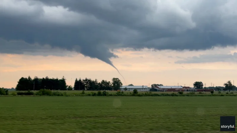
The distinction between the alerts is plain enough, but the pace of a storm is not. Tornadoes ripped through parts of northern Illinois during a severe weather outbreak last week, and the region has already seen damage from recent storms, including a tree down on West Jefferson Street in Joliet and a fallen tree in front of a house in Bartlett. In this stretch of weather, the practical answer is not to wait for the most serious label. It is to stay informed, treat a watch as the moment to get ready, and move the second a warning appears.
Thunderstorms follow the same pattern in simpler form: there are only two levels, a watch and a warning. If a thunderstorm watch is issued, severe storms are possible. If a warning follows, residents should stay informed and be ready to act. For now, Tuesday begins the next round, Wednesday raises the stakes, and the alert that matters most is the one people notice early enough to use.
