Tropical Storm Watches were issued Tuesday for portions of the Upper Texas and southwestern Louisiana coasts as a slow-moving tropical disturbance near South Texas threatened heavy rain, flooding and a possible tropical storm later this week.
At 11 a.m. EDT Tuesday, the National Hurricane Center designated Invest 90L as Potential Tropical Cyclone One, a label it uses when a system is not yet a tropical depression or tropical storm but is close enough to land to bring significant impacts. The designation also lets forecasters issue Tropical Storm Watches and warnings, which is why the watch now stretches into an area where residents have already seen heavy rain and where more than 10 inches of additional rainfall could still fall by late this week.
That forecast is why the flood watch matters now. The storm has already drenched a flood-prone stretch of the Gulf Coast, and the added rain could turn scattered street flooding into something far more dangerous very quickly. Residents along the Gulf Coast were being urged to stay prepared for heavy rainfall this week, with flooding described as a significant threat that could become life-threatening in a short time.

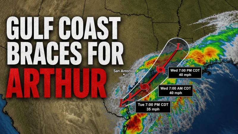
For now, the disturbance remains inland near South Texas, which is the main reason it has little chance of developing while its center stays over land. Satellite imagery showed that center still inland Tuesday morning. But the system could move over Gulf waters later Tuesday or Wednesday near the Texas Coast, where water temperatures were at least 83.5°F, and that would give it a brief window to organize before it heads back over land later this week.
The forecast models show that the rain threat is bigger than the name. The GFS model points to a brief closed circulation forming later today just southwest of Corpus Christi, with the deepest convection spreading along the southeast Texas Coast and into southern Louisiana through Thursday morning. It puts the highest totals over southern Louisiana and southern Alabama, with isolated spots topping nine inches. The European model is more aggressive, showing broader convection across much of the Texas Coast and rainfall totals that could exceed six inches over many areas.
Whether the system becomes Arthur or never gets that far, the immediate issue is already clear: a slow-moving disturbance can flood an area without first becoming a named storm. If it reaches the Gulf soon enough, it may strengthen; if it does not, it can still deliver the kind of rain that overwhelms roads, homes and drainage long before anyone can focus on the forecast cone.