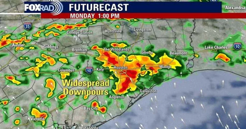
FOX 26 issued a Storm Alert for Monday as storms and heavy downpours were expected to spread across Southeast Texas and linger through Wednesday. The forecast points to a wetter stretch driven by tropical moisture colliding with a stalling front, with isolated rainfall totals of 6 to 8 inches possible by midweek.
The alert lands after parts of Harris County and Montgomery County were already under a Flood Advisory until 9:30 p.m. Sunday. By 7:30 p.m., the National Weather Service said 1 to 2 inches had already fallen, and another 1 to 2 inches was expected Sunday night, a pace that is enough to push low-water spots and quick-drain streets into trouble before Monday even arrives.
John Dawson, who delivered the outlook on FOX 26, said the region is heading into a stretch of increasing wind and humidity, the kind of setup that usually turns scattered showers into a more stubborn rain event. For people watching Austin Weather search trends, the important part is not a single burst of rain but the length of the event: periods of moderate to heavy rain are expected through Wednesday, with 2 to 5 inches of rain possible across the area.
That forecast still leaves room for a sharp mismatch between where rain falls hardest and where people think it will. The area was under a 2/4 risk for street flooding on Sunday, and that level was expected to continue through Tuesday, which means localized flooding is possible even if the rain does not reach the higher end of the totals. In practical terms, 2/4 is a moderate street-flooding risk, lower than the most serious level but high enough to make repeated downpours a problem for roads, drainage and commutes.
What keeps the setup unsettled is that the system bringing the moisture is not a clean, organized storm. A weak tropical low and a front dropping in from the north are helping feed showers now, while a weak area of low pressure along the coast of eastern Mexico remains disorganized. It could re-emerge in the Gulf Tuesday or Wednesday, but conditions for further development are still low, which means the concern is less about a named tropical system growing stronger than about how much rain can pile up under slow-moving storms.
That is why Monday matters. The rain threat has already started, the advisory is already in effect, and the heaviest part of the forecast is still ahead. If the moisture shifts west, the next question will be how far the heavier bands reach and whether the totals stay in the 2 to 5 inch range or climb toward the isolated 6 to 8 inch amounts that would turn a wet stretch into a flooding problem.