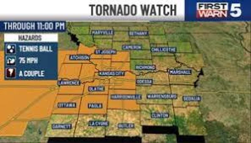
A tornado warning was issued for Jackson County until 9:15 p.m. Saturday as severe weather moved across parts of the Kansas City metro, with other nearby counties also under warnings and watches.
For residents in Jackson County and the surrounding metro, the timing matters because the strongest threat was expected between 8 p.m. and 11 p.m., right when the evening’s severe weather was expected to peak. Clay, Platte and Wyandotte counties were also under a tornado warning, while Jackson, Cass, Johnson and Miami counties were covered by a Destructive Severe Thunderstorm Warning until 9 p.m. with damaging winds up to 80 mph possible. A Tornado Watch remained in effect through 11:00 pm tonight, and a Flood Watch covered the metro and areas to the south through tomorrow morning.
Saturday was a First Warn Weather Day, and the threat was not uniform across the region. The severe risk included damaging winds, hail and possibly a couple of tornadoes, but not every spot was expected to see severe storms. The lower, though still present, threat to the north covered Nodaway, Holt and Andrew counties under a Severe Thunderstorm Watch through 11:00 pm.
After the evening rounds of storms, conditions were expected to calm down overnight. Sunday was projected to turn cooler, less humid and more comfortable, with temperatures rising to 73. The workweek was expected to stay dry through Monday, before a 30% chance of isolated showers and non-severe storms Tuesday and a 50% chance of storms Wednesday, when wind gusts could reach 40 mph. Wednesday was also a First Warn day, which means another round of weather would be watched closely even after the current warnings expire.