A severe thunderstorm warning covered most of the Kansas City area until 3:15 a.m. Monday as a line of storms moved through before dawn, bringing a risk of dangerous winds, hail and the chance of tornadoes. A flash flood warning was also in effect for Wyandotte County, Kansas, and Clay and Platte counties in Missouri until 8 a.m.
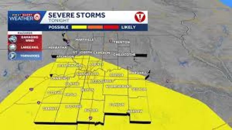
That is why people were searching for tornado warning Kansas City in the middle of the night: the threat was not limited to rain. Severe hazards of all kinds were possible overnight, and the Storm Prediction Center had the metro and areas to the south under a 2/5 severe risk. Officials also warned of low-level flooding and ponding as heavy storms passed through the region.

The weather setup was broad and unsettled. A severe thunderstorm watch had been posted for the Kansas City metro through 4 a.m. tonight, and the overnight period carried the strongest risk, with tennis ball-size hail, wind gusts near 70 mph and a tornado or two possible. Even as the warning clock ticked down, the threat was moving through neighborhoods before sunrise rather than building later in the day.
That made Monday's forecast unusual in a way that mattered to anyone looking out the window after dawn. The day was expected to turn mostly sunny, dry and muggy, with only a 20% chance for storms, even after overnight storms brought the risk of tornadoes and flooding. In other words, the worst weather was tied to the hours before sunrise, not the hours people would spend outside later in the day.
The sharpest question now is not whether the metro will stay under warnings all day; it will not. The severe threat was expected to ease through mid-week as conditions dried out, before rain and storm chances return as early as Thursday, with higher odds of wet weather Friday through the weekend. For Kansas City, the immediate danger was the overnight pulse of storms, and the next concern is how quickly the region clears before the late-week round arrives.