


Scattered thundershowers developed Wednesday afternoon across the Birmingham area and drifted off to the north-northwest, bringing pockets of heavy rain and reduced visibility but no severe storms. In the areas that stayed dry, temperatures climbed into the low to mid 80s with a heat index approaching 90°F.
The rain was expected to fade after sunset Wednesday evening, but the break looked short-lived. Temperatures should cool near 70°F by Thursday morning, though patchy fog remained possible overnight where showers fell during the day.
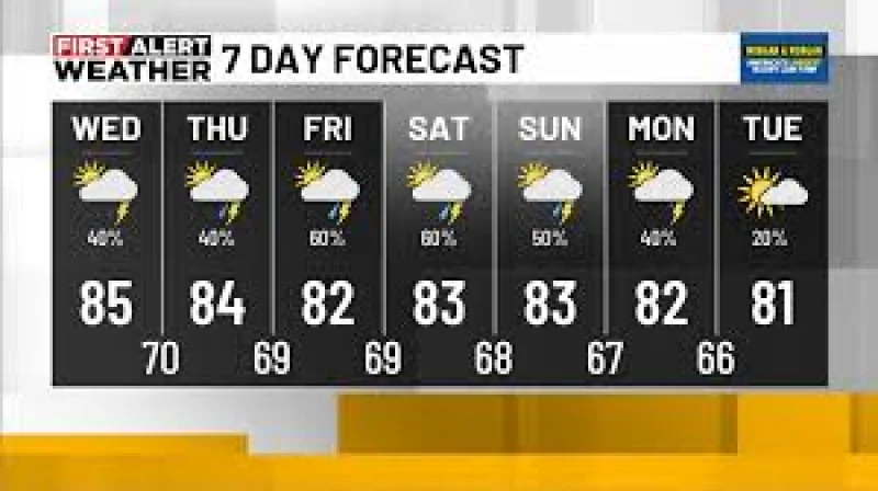
More scattered storms are expected to return Thursday, with the best chance for showers and thunderstorms between noon and 6 p.m. CDT. Skies should stay mostly cloudy, highs should reach the low to mid 80s, and the heat index could climb into the upper 80s to near 90°F. The main concern Thursday afternoon is pockets of heavy rain and lightning, and a strong storm cannot be ruled out, though the threat is low. Not everyone will see rain.
The bigger change comes Friday into Saturday, when a stationary front is expected to lift northward and stall across north and central Alabama. Waves of energy along that boundary could keep scattered showers and storms going, with rain chances rising to 60% to 70% and highs holding in the lower 80s. Heavy rainfall is possible during the afternoon and evening, and forecasters plan to watch a low-end flooding threat because of the moisture already in place.
That pattern does not end quickly. Scattered storms are expected to continue Sunday into Monday, though coverage should be lower than late week. Rain chances fall to 40% to 50%, highs stay in the low to mid 80s, and overnight lows slip into the upper 60s Sunday and Monday night.
Long-range guidance hints at a possible short-lived change around June 2-3, 2026, when slightly drier air could filter into Georgia and the northern half of Alabama. If that happens, conditions would turn less muggy, highs would ease slightly below average into the lower 80s, and overnight lows could dip into the mid 60s. Another surge of Gulf moisture is then expected around June 5-7, and most guidance does not support a tropical system during that period. The more likely outcome is a stalled boundary bringing another round of rain, possibly with a weak low.
For Birmingham, the forecast is not about one isolated storm. It is a stretch of repeated rain chances, with heavy downpours already having made an appearance and more rounds likely before the pattern finally tries to dry out briefly early next month.
