A wet stretch is set to keep the New Orleans area under a near-daily threat of showers and thunderstorms through the Memorial Day weekend and into next week, with the heaviest rain and the highest flood risk expected on Sunday. The region will not face a full washout, but anyone making outdoor plans should be ready for abrupt changes, especially in the afternoons.
Abundant moisture and a steady stream of disturbances moving through the atmosphere will drive numerous showers and thunderstorms each day across the Baton Rouge area, and the pattern should spill over the holiday period with enough rain to make indoor backup plans a smart move. Localized flash flooding is the main concern, especially in poor drainage spots and urban areas, where about 4 to 7 inches of rain could trigger street flooding and water over low-lying roads.

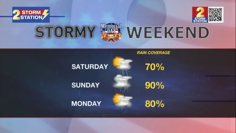
Early showers and thunderstorms tonight and again tomorrow are expected to taper off, leaving partly cloudy skies and quiet conditions past midnight. It will stay muggy, with lows in the low 70s tonight and tomorrow night. By Saturday afternoon, another wave of energy in the atmosphere will fire up numerous showers and thunderstorms, with rain coverage expected to be high by late afternoon after temperatures climb into the mid 80s.
Sunday is shaping up as the day with the greatest flooding threat of the weekend. A potent wave of energy will track right over the Bayou State, and nuisance street flooding could become more likely with each passing storm. Monday may be a little quieter, but numerous showers and thunderstorms are still likely, so finding a completely dry window for outdoor events will be difficult, though not impossible.
The unsettled pattern does not end with the holiday. Daily rounds of afternoon showers and thunderstorms are expected Tuesday through Friday in the shortened workweek ahead, and another 4 to 7 inches of rain could fall over the next seven days. Daytime highs will stay pinned in the mid-to-upper 80s, while nighttime lows remain stuck in the low 70s thanks to clouds and humidity. For people in New Orleans, the forecast points to a soggy week, not a shutdown week, with flood-prone neighborhoods needing the closest watch.