The Great Lakes region turned cooler and much less humid today on the backside of a cold front, with north winds bringing in colder air and holding highs in the low to mid 60s under mostly cloudy skies. Areas farther north and east stayed in the 50s, and while a bit of drizzle could not be ruled out, most places stayed dry.
That put the region below its normal high of 72 degrees and made it feel more like a brief early-spring return than the start of Memorial Day week. Tonight, temperatures were expected to fall into the upper 30s to low 40s, or ten-plus degrees below normal.

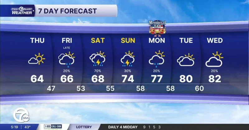
Clouds were expected to decrease Thursday and give way to some sunshine, with highs in the lower 60s. Friday should bring a slight rebound into the mid 60s, but it also carries the next chance of rain. Showers were expected to develop Friday evening and continue into Saturday, when the first half of the weekend is expected to be rainy and could include storms.
Saturday afternoon temperatures were expected to reach around 70 degrees, then climb into the mid 70s Sunday and Monday, including Memorial Day. Scattered rain chances were expected to remain both days, making the weekend a warmer one, but not a fully dry one.
The pattern points to a short cool-down before temperatures rise again, with rain chances still several days away and still subject to change. For anyone tracking weather Detroit into the holiday weekend, the immediate takeaway is simple: the chilly air does not last long, but the wet stretch may arrive right when plans begin.