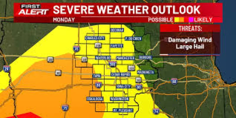
Severe storms were still not fully ruled out late Monday evening as a line of showers and thunderstorms was expected to move into the TV9 viewing area around 9 p.m. and track northeast through about 2 a.m. The best window for the First Alert Day threat was expected to run from about 9:00 p.m. to 2:00 a.m., with damaging winds and large hail the main concerns.
The far southwestern fringe counties had briefly been in an enhanced risk area, though that risk was pared back during the afternoon. Most of the area remained in a slight risk for severe weather, and forecasters said an isolated tornado could not be ruled out, especially to the southwest. The storms were expected to weaken as they moved northeastward, and overnight activity was expected to dwindle to just showers.

The reason the threat was not higher was simple: overnight shower and storm activity had already chewed up much of the moisture and energy needed for a more robust severe-weather setup. That left Monday night with enough instability for a few strong storms, but not the kind of widespread outbreak that had been possible earlier in the day. The timing still mattered because the storms were arriving during the late evening and overnight hours, when many people are asleep and more likely to miss warnings.
Behind the cold front, northwesterly winds were expected to usher in a cooler and drier air mass for several days. Tuesday was expected to be blustery, with a good amount of cloud cover early and highs slowly working into the low to mid 60s after starting in the 50s. Wednesday and Thursday were expected to look very similar, with lows in the 40s and highs in the 60s.
There is still one more round to watch. A chance for more rain and storms was expected later in the week, especially around Friday, but the risk for severe weather with that system appeared very low. For now, the biggest concern is the late Monday night window, followed by a wet and cool end to the work and school week if the later system arrives as expected.