


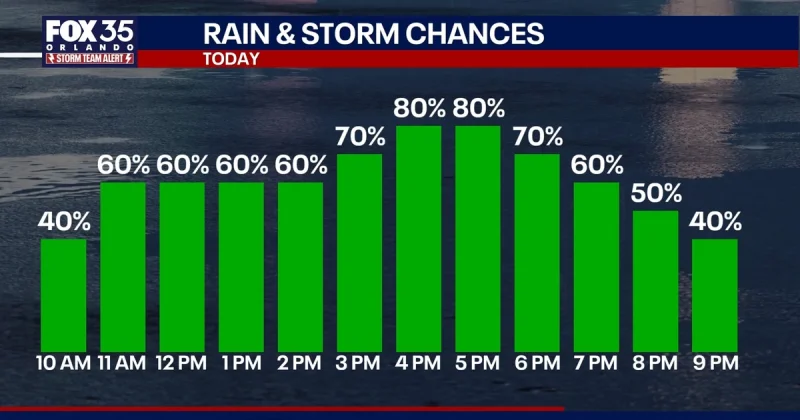
FOX 35 has issued a Storm Team Alert for Thursday as scattered heavy rain and storms move through Central Florida, with the most intense round expected from about 1 p.m. through 9 p.m. Heavy rain is expected to be the biggest impact, and slow-moving downpours could lead to flooding and flash flooding in spots.
Brooks Garner is tracking a pattern that is active now and far from brief. The main round of rain is expected to start around 11 a.m. to noon, then more waves of heavy rain are expected Friday and Saturday, which are forecast to be the soggiest days with a 70% chance of rain. High temperatures will stay in the low 90s through the weekend, so the air will remain hot and humid even as the rain chances climb.

The timing matters because the heaviest rain is not waiting until nightfall. It is aimed at the middle of the day and the evening, when repeated slow-moving downpours can quickly overwhelm low-lying streets and drainage areas. A few isolated strong storms are also possible, bringing gusty winds and plenty of lightning. People in Central Florida should expect breaks in the rain, but those pauses will not mean the threat is gone, and the next round can return with enough force to produce heavy bursts again.
By the end of the weekend, an average of 2 to 4 inches of rain is possible across Central Florida. That does not mean every spot will see the same amount, but it does point to a widespread soaking rather than a quick shower pattern. The active setup is expected to continue at least into Saturday before a more typical pattern returns next week, with daily rounds of sea breeze-driven afternoon downpours and storms. For now, the focus stays on Thursday’s window from late morning through the evening, when the wettest stretch is expected to arrive.
