


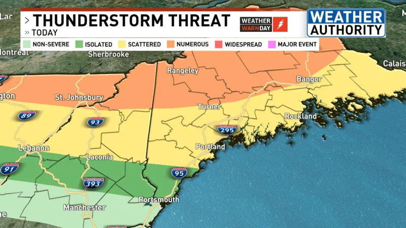
Wildfire smoke drifting into the region is taking the edge off the heat in Maine today, but it is not slowing the storm threat that builds later. Severe thunderstorms are expected on Tuesday, and the setup turns more dangerous by evening as a very strong cold front pushes through.
That is why people are watching air quality in Boston and beyond now: the smoky sky is changing how the day feels, while the atmosphere still lines up for damaging winds, large hail, flooding, and tornadoes. Heat advisories remain in effect until 8 p.m. this evening, yet the smoke is keeping temperatures cooler than originally thought instead of letting the area fully warm.

The strongest signal points to the mountains and northern New Hampshire, where numerous severe thunderstorms have the greatest chance to develop. Showers and thunderstorms could reach northern Franklin and Somerset counties as early as 1 PM, while the mountains may see them from about 4 to 7 PM. Dew points will be running in the 60s on Tuesday, a sign the air will stay sticky enough to fuel storms even with the smoke overhead.
There is one catch: the smoke is helping cap the heat, but it is not expected to stop thunderstorm development this afternoon. The sky may look yellow-ish or orange, but that haze is only shaving down temperatures, not removing the energy that a strong cold front can tap into. NOAA's Storm Prediction Center has even issued a very rare 10% risk, which is a clear signal that the atmosphere is not just unsettled, it is capable of producing serious weather.
For People in Maine, especially campers and anyone in the storm path, the next few hours matter more than the smoky conditions themselves. Lower humidity is expected throughout Wednesday as refreshing air rushes in, but before that arrives, Tuesday evening is the window that could decide how severe the day becomes.
