


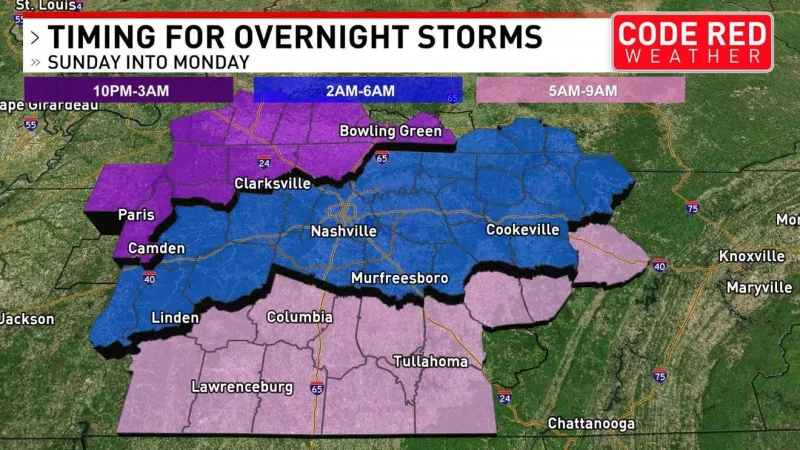
A First Alert Weather Day is in effect for tonight and Monday as strong-severe thunderstorms move into Middle Tennessee overnight, bringing the biggest risk of damaging wind. The storms are expected to arrive just before midnight from the north, reach Nashville around 1 a.m. and then continue into Monday with more rain and storms.
The timing matters because the first round arrives while many people are asleep, and the strongest storms are not expected to be evenly spread. Northwest Middle Tennessee and southwest Kentucky have the greatest chance of seeing severe weather, while the storms should weaken as they push southward.

Damaging wind gusts are the greatest concern, but there is also a very low chance for an isolated tornado near the TN/KY line. That risk is part of why the overnight period has been marked as a First Alert Weather Day, even though the overall severe threat is not expected to be long-lived.
Monday brings a second window for stronger storms, mainly along and near the Cumberland Plateau from mid-afternoon through early evening. Wind, hail and an isolated tornado will be possible there, and the severe threat is expected to be done by mid-evening. A few storms on Monday could also be strong farther east in Middle Tennessee.
After that, the pattern briefly settles. Low rain chances return Wednesday and Thursday, another batch of storms is likely late Friday, and drier, hotter weather is expected next weekend. For now, the bigger question is not whether storms will come through, but how strong the first overnight line is when it reaches northwest Middle Tennessee and southwest Kentucky.
