A severe weather outbreak is tearing across parts of the Midwest on Wednesday, with confirmed large and extremely dangerous tornadoes, more than 70 wind reports and damaging hail already on the board. The storms are not done yet. They are still firing as they shift into the Ohio Valley overnight, and the same system is expected to reach the East on Thursday.
The most immediate concern is the mix of damage and distance. A tornado was reported near Harpers Ferry by the Wisconsin and Iowa border, another near Charleston, Illinois, and large and extremely dangerous tornadoes were also reported in Spencer and Martinsville, Indiana. A tornado was reported near Springfield Capital Airport, Illinois, as numerous tornado warnings spread across the Midwest, showing just how broad the hazardous weather outlook has become.
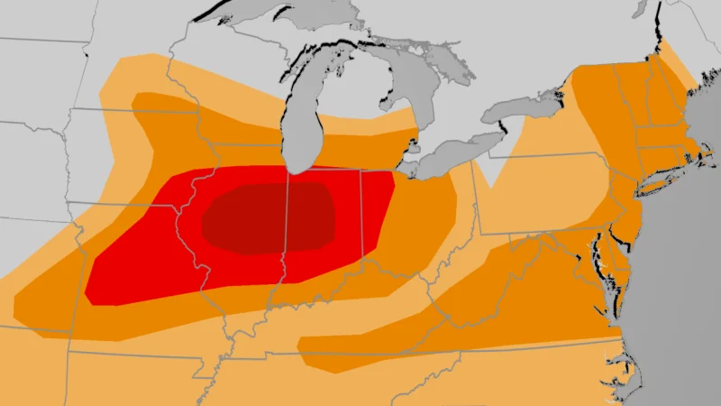
That breadth matters because the line is not weakening enough to stop the risk. Swaths of damaging wind gusts and tornadoes are still possible, and some of the tornadoes could be at least EF2, the kind that can cause major structural damage. The storm complex is also carrying a significant flash-flooding threat in Chicagoland and northwest Indiana, where rainfall rates could reach as high as 2 inches per hour, fast enough to overwhelm drainage in a short window if the heaviest rain trains over the same place.
The system is moving at a moment when the Midwest is already storm-weary. Wednesday morning's derecho hit the region before another line of severe thunderstorms developed and marched east, and the pattern is continuing into the overnight hours even as the threat is described as diminishing. That slowdown does not mean safety: damaging winds and tornadoes remain possible before daybreak, which is why the weather service in LaCrosse, Wisconsin, is sending out a survey team at 7 A.M. Thursday to sort out what has already touched down.
By Thursday, the focus shifts again. The frontal system reaches the East, where at least scattered thunderstorms could turn severe with damaging thunderstorm wind gusts. New York City, Philadelphia, Baltimore and Washington, D.C. could be included in the severe weather area, after the same broader region was hit by a severe weather outbreak last week that produced more than 1,700 storm reports between June 7 and 12. For people watching this from the Midwest to the East, the next answer is not whether the setup is active. It is how many tornadoes, including any at least EF2, will be confirmed after the surveys and how far the risk pushes into Thursday.