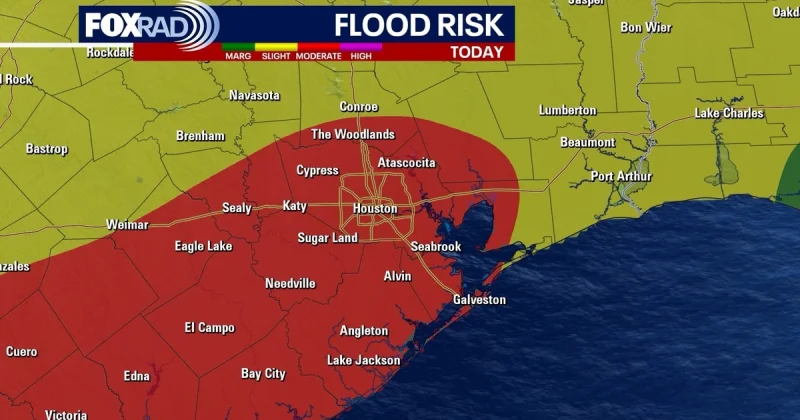
Houston is under a flood watch through Wednesday at 7 am as rain and thunderstorms move in with the chance for heavier downpours and flooding. The National Weather Service says the city could see 2 to 4 inches of rain over the next few days, with isolated spots not ruled out for 6 to 8 inches.
Brittany Begley said the highest street flooding threat in Houston is expected on Monday, and she warned of the potential for a Monday washout. The setup is being driven by tropical moisture from the Gulf, and the rain threat is landing on a day when more than 68,000 fans were expected at Houston Stadium at noon, with another 15,000 visitors cycling through FIFA Fan Fest each day.

The risk is not just the amount of rain. The peak window for lightning and heavy rain is expected between 2 and 8 p.m., with a 60% chance for lightning around Houston Stadium. At the FIFA Fan Festival, any lightning detected within an 8-mile radius would force fans off the grounds and into a safe location, and the gates would not reopen until 30 minutes passed without any additional lightning.
That makes the day a test of timing as much as weather. Rain totals from Sunday to Tuesday were expected to run from 1 inch to 3 inches overall, with a few places getting 5 inches to 6 inches, while organized thunderstorms were expected to move out of Southeast Texas by early afternoon Tuesday. Hit and miss storms were still possible on Wednesday, and Houston is expected to turn hot and humid on Thursday.
For now, the most important question is how much of the rain will fall in the city itself and how much will be confined to isolated pockets. The forecast already points to enough water for street flooding in the worst spots, and enough lightning risk to interrupt crowds at Houston Stadium and FIFA Fan Fest before the weather pattern eases later in the week.