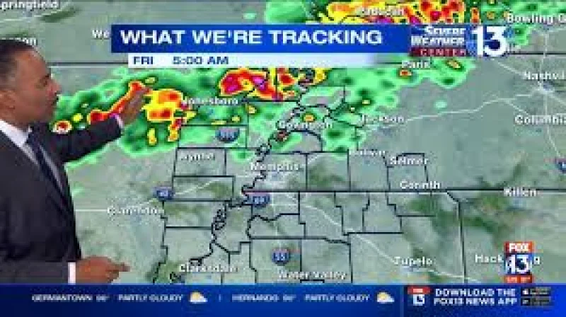
Scattered storms are expected to break out across the Mid-South on Friday as temperatures climb into the mid to upper 80s, bringing brief downpours to parts of the area during an otherwise mostly cloudy day. Clouds were already thickening by Friday morning, when temperatures started in the upper 70s around sunrise.
That makes Friday a day for people with outdoor plans to keep an eye on the sky, especially in Memphis and nearby communities where humidity is expected to hang on and make the air feel heavier through the afternoon. The rain chance is not the same everywhere, which means some neighborhoods may stay dry while others get hit by quick, passing showers and storms.
After the Friday system moves through, temperatures are expected to ease only slightly overnight, falling gradually through the 80s into the mid 70s for lows around sunrise Saturday. Passing clouds are expected overnight with mostly dry conditions, setting up a Saturday that is partly cloudy and brighter than Friday with more peeks of sunshine.

Saturday is where the forecast gets a little uneven. Most of the area is expected to stay dry, but northernmost areas carry a 1/5 risk for severe storms. Even with that limited threat, highs are expected to warm near 90 degrees, and humidity will make it feel more like the mid 90s for much of the day.
The broader pattern suggests this is not a one-day rain event. Scattered showers and storms are expected to return Sunday and Monday, when highs should settle into the lower to middle 80s, offering a small break from the weekend heat but not a full end to the wet spell. By midweek, drier weather with more periods of sunshine is expected, and temperatures are forecast to surge back into the 90s.
For now, the main story is a humid Friday with scattered storms, a mostly dry Saturday for most of the Mid-South, and another round of rain early next week before the region turns hotter again.