Freeport and 15 counties in northern Illinois are under a severe thunderstorm watch until 7 tonight, with the National Weather Service warning that storms could bring damaging wind, hail, heavy rain and even tornadoes. The watch covers Stephenson, Boone, Bureau, Carroll, De Kalb, Henry, Jo Daviess, Lee, McHenry, Mercer, Ogle, Putnam, Rock Island, Whiteside and Winnebago counties.
The watch is in place as a front moves eastward from the Northern Plains and Central Plains toward the Great Lakes, triggering showers and severe thunderstorms across the Upper and Middle Mississippi Valley and the Great Lakes region. The Storm Prediction Center has placed parts of that area under an Enhanced Risk, level 3 out of 5, through Thursday morning, a signal that severe weather is more than a passing possibility.
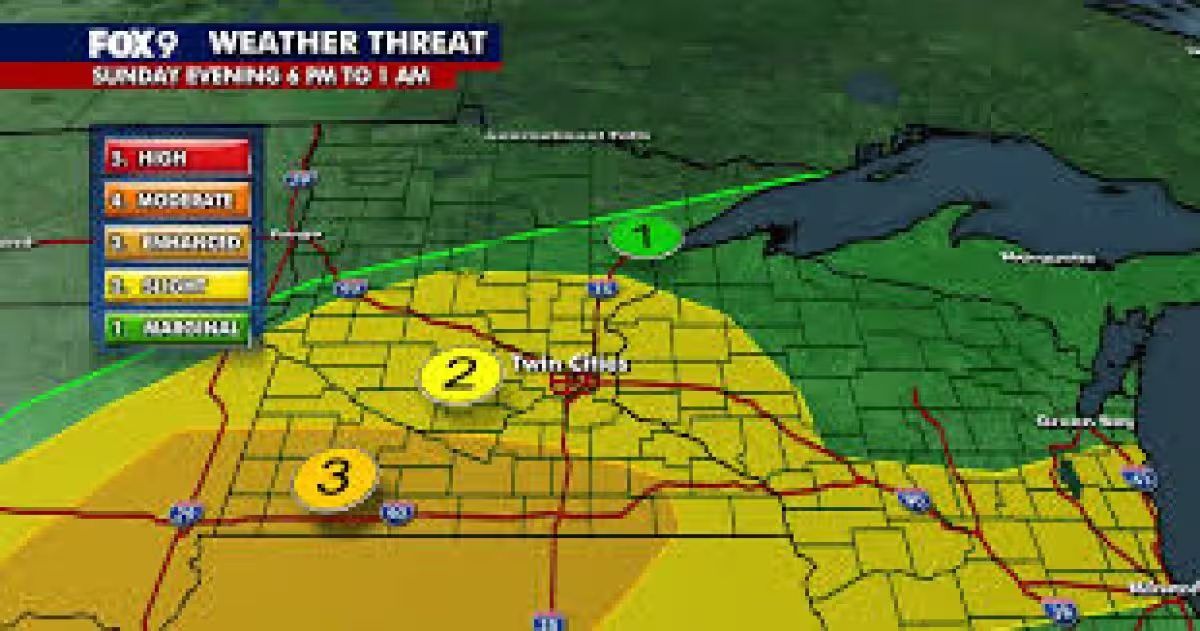
The biggest concern is not just rain, but how hard it falls and where it lands. The National Weather Service says the storms could produce frequent lightning, severe wind gusts and hail, while the associated heavy rain could lead to localized flash flooding. Urban areas, roads, small streams and low-lying spots are most vulnerable, but the exact threat depends on rainfall intensity, location, land use, topography, vegetation, soil type and how much water the ground is already holding.
That is why one neighborhood can flood while another nearby stays dry. The Weather Systems Processor has also issued a Slight Risk, level 2 out of 4, of excessive rainfall over parts of the region through Thursday morning, reinforcing that the rain threat is broad even if the flooding is not. Flash flooding can begin within six hours of heavy rain and often within three hours, giving little time for water to rise across streets and small streams.
For people in the watch area, the next question is whether the storms stay within the severe thunderstorm watch or intensify into something more dangerous. The National Weather Service says tornado watches mean tornadoes are possible in and near the watch area, while tornado warnings mean a tornado has been sighted or picked up by radar and warnings are issued by the local forecast office. For now, the active risk is immediate, and it runs through 7 tonight.