A strong cold front is set to sweep through southern Minnesota and northern Iowa between tonight and Wednesday, bringing a round of strong to severe storms that will hit the west first and then slide east toward the Interstate 35 corridor later in the day.
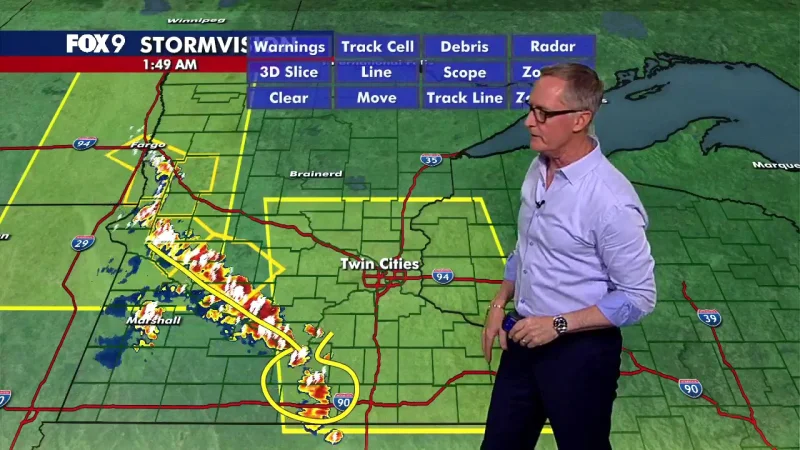
That matters now because the first storms are expected to arrive overnight, with showers and thunderstorms moving in from the Dakotas into southwestern Minnesota and northwestern Iowa between 11 p.m. and midnight, before the line pushes east across southcentral Minnesota and northcentral Iowa between 2 a.m. and 4 a.m. as it heads into Wisconsin. The main threat overnight is damaging wind and gusts, though isolated large hail is possible and a tornado, while unlikely, cannot be ruled out.

Today will feel like the calm before the change. Skies will stay mostly sunny, temperatures are expected to top out in the low-90s, and the heat index will climb into the mid to upper-90s. South and southeast winds of 10 to 20 mph could gust to 30 mph at times, adding to the muggy feel before the front arrives.
The sharper risk comes Wednesday afternoon and evening, when the actual cold front develops and moves east into Wisconsin. The severe threat is low in the west by then but rises farther east along and east of I-35, where all modes of severe weather will be possible, including damaging winds, large hail and a few tornadoes. Storms are projected to develop along I-35 after 4 p.m. and move east of the corridor between 6 p.m. and 7 p.m., with the threat easing in western and central areas between 3 p.m. and 5 p.m., along I-35 between 7 p.m. and 8 p.m., and in southeastern Minnesota and northeastern Iowa between 8 p.m. and 10 p.m.
Once the front clears, temperatures will fall into the mid-70s by Wednesday morning, then into the mid-60s by Thursday morning. Skies should gradually clear, and after this burst of heat and storms, the rest of the week and the upcoming weekend look quieter, with only a slight chance of a few non-severe showers Thursday morning and isolated showers late Friday into Saturday morning.