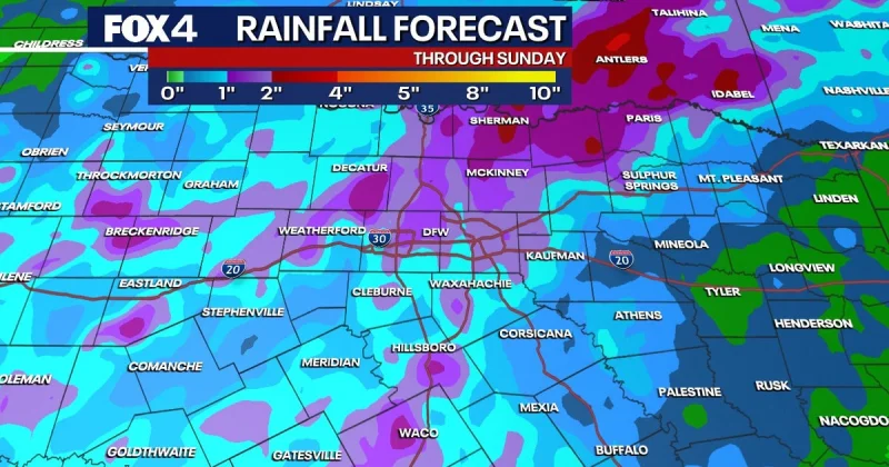
North Texas is heading into a wet weekend, and the main concern is not just rain but flash flooding. Multiple rounds of showers and storms are expected through Sunday, with the heaviest weather likely to arrive Saturday.
Ali Turiano said residents should prepare for a wet weekend as locally heavy rainfall moves through North Texas, bringing a threat of flash flooding before summer-like heat arrives next week. The National Weather Service said the storms could also bring gusty, erratic winds, frequent lightning and heavy downpours.
Friday starts the pattern with isolated and scattered thunderstorms across parts of North Texas, followed by widespread scattered storms Friday night. The setup becomes more active Saturday, when multiple rounds of rain are expected and the chance of rain is highest. Locally heavy rainfall is possible from morning through evening, and flash flooding is the primary threat throughout the weekend.
That risk does not mean rain will fall nonstop. Temporary lulls in precipitation are possible even on the wetter day, but the same system will keep feeding scattered, heavy downpours into Sunday. The weekend pattern is being driven by an area of low pressure to the southwest, which is helping steer repeated rounds of storms across the region.
For people headed out on area lakes, the weather adds another reason for caution during the storms. The good news comes quickly after that: high pressure is expected to build over the region next week, cut off rain chances and push highs consistently into the 90s starting Monday, with heat index values approaching triple digits at times. For North Texas, the flood warning window is short, but the impact could be sharp where the heaviest rain falls.