A wet and unsettled weather pattern is lining up across South Mississippi and the Gulf Coast heading into the holiday weekend, and it is not a quick hit. Rain chances begin increasing tonight, with scattered showers and thunderstorms becoming more widespread overnight as the first round of moisture moves in.
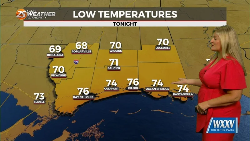
That means some areas could pick up locally heavy rainfall before daybreak, while overnight lows hold in the mid 70s and keep the air warm and muggy. Friday brings another round of showers and thunderstorms, especially during the morning and afternoon hours, with temperatures climbing into the lower 80s.

The weekend does not offer much of a break. Scattered to numerous showers and storms are expected on Saturday and Sunday, and outdoor plans may need flexibility because storms could develop at almost any point, especially during the afternoon and evening hours. High temperatures are expected to stay in the low to mid 80s, which will keep the atmosphere primed for more showers as the day wears on.
Memorial Day itself is also expected to bring off-and-on showers and thunderstorms throughout the day, extending a stretch of daily rain chances into the middle of next week. The forecast does not point to widespread severe weather at this time, but stronger storms could still bring heavy downpours, lightning and brief gusty winds.
The bigger concern in places that keep getting hit is water on the roads and drainage problems. Localized ponding could build up where repeated heavy rainfall falls in a short period, especially in low-lying spots and areas that do not drain well. This is a pattern forecast, not a single storm, and it is the kind that can keep changing the feel of the holiday weekend hour by hour. For now, the best reading is simple: rain and storms are likely to stay in the picture from tonight through the middle of next week.